is your shadow!
The de Wet family looming over the Mahai stream, in the Royal Natal National Park.
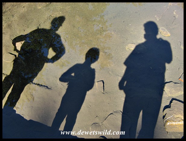
“Beneath your feet” is the theme for this week’s WordPress Photo Challenge

is your shadow!
The de Wet family looming over the Mahai stream, in the Royal Natal National Park.
“Beneath your feet” is the theme for this week’s WordPress Photo Challenge

My sister, Ansie, and I headed to the Kruger National Park for a 5 night visit in the early morning of Friday 17th July. After our latest trip to Hluhluwe-Imfolozi Park, Marilize had business to attend to and Joubert had to be back at school the following Monday, as the winter school holidays had come to an end. This therefore was a great opportunity for some sibling bonding in a place where we’d spend many wonderful days together growing up. Just a few hours easy drive along the N4-highway got us safely to Malelane Gate, on the southern border of the reserve, at around 08:30.
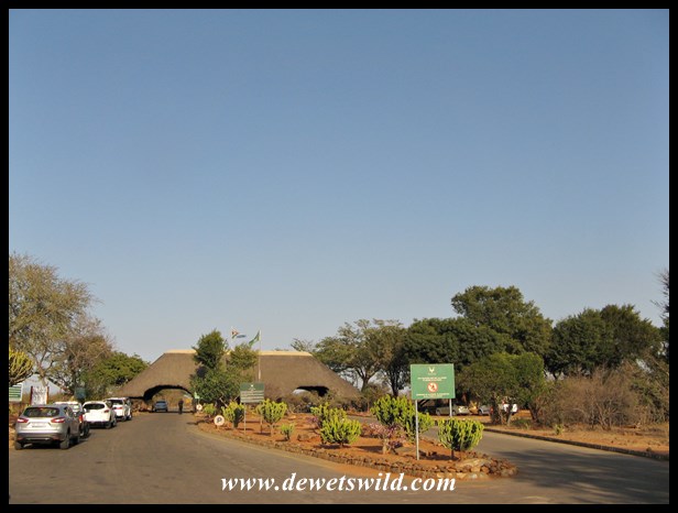
Malelane Gate, always a welcome sight after the drive from Pretoria
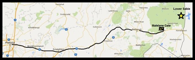
The route from Pretoria to Malelane, approximately 380km (drawn with Google Maps)
Just a few minutes spent getting our entry permit issued and to send a few quick text messages to let the loved ones back home know we arrived safely, before setting off into the Park. Our route took us along the S25 Crocodile River drive to Lower Sabie Rest Camp, where we’d booked the next two nights in a safari tent on the bank of the Sabie River.
")
")
")
")
")
")
")
")
")
")
After checking into our accommodation and unpacking the luggage and supplies, it was time to get back on the road again for our afternoon drive. We opted for just a short drive past Duke’s waterhole and Nthandanyathi Hide to the south of camp, and spent the last few minutes before the gates closed enjoying a magnificent sunset from the causeway over the Sabie just outside camp.
")
")
")
")
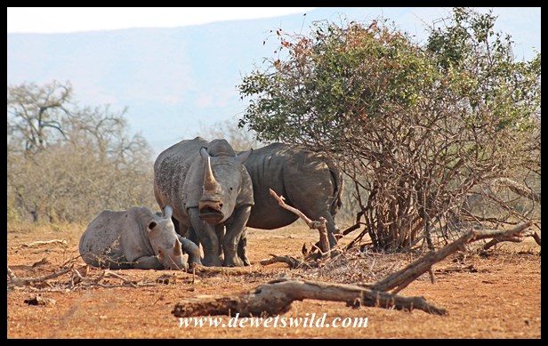
We awoke early on Saturday morning, eagerly anticipating what Kruger would have in store for us that day. We decided to stay out all day, and were one of the first vehicles waiting at the camp’s gates to open at 06:00. Lower Sabie’s renowned for predator sightings, which explains why it is so popular among visitors and often fully booked months in advance. Not long after leaving camp we encountered a pride of lions near Lubyelubye, keeping Lower Sabie’s reputation intact. After being robbed of our breakfast rusks by a big baboon at Nkuhlu Picnic Spot, we continued along the Sabie and onwards to Transport Dam via the S65-route. From there we had to get past a considerable traffic jam (where two lionesses, apparently with well-hidden cubs, were baking in the sun on a rocky outcrop), to get to Skukuza, where we enjoyed a picnic-lunch at the day visitors area near the Selati railway bridge. To get back to Lower Sabie, we chose the S21 Nwatimhiri Road, a gravel route that follows the course of the mostly dry stream of the same name. We were one of the first cars out that morning and one of the last to return to Lower Sabie that evening, just minutes before the gates closed at 17:30 – a long but very rewarding day in the wilds of the Kruger National Park.
")
")
")
")
")
")
")
")
")
")
")
")
")
")
")
")
After dinner, it was time to take our usual stroll through the camp, taking some night time photos along the way, before turning in.
")
")
")
Sunday was another early start to the day – we had to pack and head to Satara Rest Camp, northwards from Lower Sabie. We detoured to Mlondozi Picnic Site for breakfast, and ticked a quick leopard sighting (no photos unfortunately) about half-an-hour after leaving camp, completing the Big-5 for the trip less than two days into our visit. A quick pit-stop at Tshokwane and then arrived at Satara just in time for lunch, under the watchful eye of several of the camp’s feathered inhabitants.
")
")
")
")
")
")
")
")
")
")
")
")
")
")
")
")
")
")
")
")
")
Satara is the departure point for the next part, and undoubtedly the highlight, of this particular trip to Kruger – the Sweni Wilderness Trail. I’ll be telling you all about this incredible experience soon, in another installment of de Wets Wild.
In the 20 years that I’ve been visiting the Hluhluwe-Imfolozi Park, I’ve never seen the Black Umfolozi River bone-dry at the bridge on the way to Mpila Camp. That changed when we visited in July 2015. A drought has the north of Kwazulu-Natal Province in its firm grasp and it is evident that the Park is unfortunately not escaping its ravages.
Travelling south-west after entering at Memorial Gate, through the Hluhluwe-section of the Park, we couldn’t help noticing how parched even this normally lush area has become, a marked contrast from when we visited in December 2014. Game-viewing was easy going, as animals were congregating in their numbers around the remaining water sources and the denuded vegetation provided little cover. After checking in at Mpila, we headed for Sontuli Loop, our favourite drive in the reserve.
")
")
")
")
")
")
")
")
The next morning saw us out exploring Imfolozi at the break of dawn. The animal population seems to be coping well with the harsh conditions and we had good sightings of several species of birds, mammals and reptiles. Unseasonably hot weather, in the low 30’s Celsius, saw us return to Mpila for a siesta during the midday heat before taking our afternoon drive to Ubhejane Hide .
")
")
")
")
")
")
")
")
")
")
")
")
Overnight a cold front accompanied by strong gusts of wind passed over the Park, seeing temperatures drop to less than half of what they were the previous day and overcast conditions prevailing throughout. This allowed us to stay out exploring for most of the day, visiting the Centenary Centre for lunch (we can highly recommend the ostrich burgers sold at the take-away kiosk!). A drive out to the extreme south-west corner of the reserve that afternoon put our minds at ease with the knowledge that the White Umfolozi River, that runs through the Park’s wilderness area, is still flowing, albeit only a trickle compared to the normal situation.
")
")
")
")
")
")
")
")
")
")
")
")
")
More of the same wintery weather greeted us as we woke on our last full day in the Park, and the hot cup of coffee and rusks we enjoyed that morning at Ubhejane Hide was indeed very welcome. By now we knew the few remaining pools at the viewpoint over the Black Umfolozi (near point 17 on the Park map) was like a magnet to wildlife, and finding three big male lions there guarding one of them was no surprise. The band of brothers remained in the same spot all day, doing what lions do best – sleeping! As for the de Wets, we headed for Sontuli Picnic Site for a lovely braai (South African barbeque) and then enjoyed our traditional last slow drive along Sontuli Loop at dusk before heading back to camp.
")
")
")
")
")
")
")
")
")
")
")
It’s unbelievable how quickly time passes when enjoying South Africa’s wild places. Leaving the Park on the morning of the 15th of July, we were concerned about the effects a prolonged drought would have on the Park’s vegetation and wildlife. Recent news about good rains falling in the area therefore was extremely welcome. It might not break the drought, but it will replenish the waterholes and hopefully carry the wildlife through to summer when (hopefully) more rain should come.

————————————————————————————————————————————–
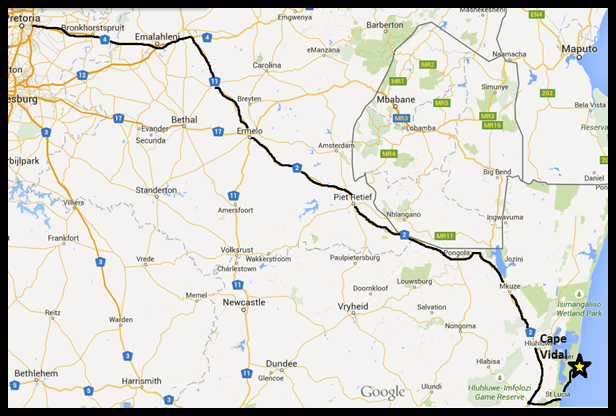
For our July 2015 visit, we opted to enter and exit the Hluhluwe-Imfolozi Park at Memorial Gate, in the north of the reserve (a 7-hour, with stops, 570km drive from our home in Pretoria), and spent four nights at wonderfully wild Mpila Camp in the Imfolozi-section of the reserve.
")
")
")
")
")

The route from Pretoria to Memorial Gate
(drawn with Google Maps)
Sadly the Hluhluwe-Imfolozi Park is under threat; if a proposed coal mine on the southern border of the reserve gets given the go-ahead it will mean the end of the reserve’s renowned wilderness area and much of its, and the Isimangaliso Wetland Park’s, ecological integrity. Visit “Save our Imfolozi Wilderness” if you’d like to add your voice in opposition to this unnecessary and unwelcome development.

iSimangaliso Wetland Park, South Africa’s first World Heritage Site, is named after the isiZulu word meaning “Miracle” and “Wonder”. Our recent visit to the Park just reminded us again what an appropriate name that is.
Having visited the Western Shores in December last year, we focused our attention during our June visit on the Eastern Shores section of the Park, a diverse area lying between the Indian Ocean in the east, Lake Saint Lucia in the west, St. Lucia town and the lake’s estuary to the south and incorporating the popular destinations of Mission Rocks and Cape Vidal, where we stayed for three nights. The sunrises and sunsets alone made the trip worthwhile!
")
")
")
")
")
")
")


As always, the game and bird-viewing on the Eastern Shores could only be described as splendid, but the Park is clearly not escaping the ravages of the drought that has Kwazulu-Natal Province in a firm choke hold, and none of the pans close to the roads held any water. Indeed a stark contrast to the lush oases of reeds and waterlilies these waterholes normally are, complete with hippos, crocodiles and wading birds in residence. Even the Mfazana Pans, where there’s a brilliant photographic hide, was little more than an almost-dry puddle of mud.
")
")
")
")
")
")
")
")
")
")
")
")
")
")
")
")
")
")
")
")
We seem to have extraordinary luck with finding leopards here and this trip was no exception, with no less than four sightings of these beautiful cats. A late afternoon sighting of a serval, a much smaller but also spotted cat, being chased by a group of lapwings as it crossed a burnt field, was a very pleasant surprise. Unfortunately we didn’t see anything more than a footprint of iSimangaliso’s spotted hyenas during this visit. On the other side of the scale, a tiny snake, the variegated slug eater, was a first-ever encounter for us and one we’ll remember just as long as any of the leopard sightings.
")
")
")
")
")
")
We can never spend enough time at this wonderful place, and you’ll understand that we were not at all pleased that our long weekend flew past in the blink of an eye. Time to start making plans for the next visit then…
The Bhangazi gate into the Eastern Shores of Lake Saint Lucia lies roughly 640km South-East of Pretoria.
(Drawn using Google Maps)
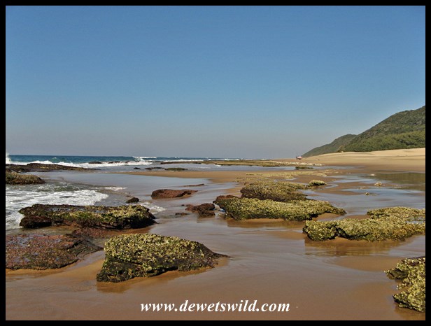
To us, there is no more beautiful a beach in this country than Cape Vidal. Miles of sand stretching as far as the eye can see, lined between densely forested dunes and the warm blue water of the Indian Ocean (in the waves of which dolphins and whales can often be seen), with rock pools harbouring fascinating marine life exposed at low tide.
")
")
")
")
")
")
")
")
")
")
")
")
")
")
")
")
Cape Vidal is named after Alexander Thomas Emeric Vidal, captain of the British surveying ship HMS Leven, that mapped this coastline in 1822. Today, this pristine area falls within the iSimangaliso Wetland Park, is one of the most popular destinations in the reserve and an excellent base from which to explore the Eastern Shores of Lake Saint Lucia. The accommodation and campsite is managed by Ezemvelo KZN Wildlife and often booked out months in advance. There’s a fuel station and a small shop selling only basic essentials, so it is best to stock-up on your groceries at St. Lucia town before entering through Bhangazi Gate 35km to the south of Cape Vidal. Apart from all the activities that the beach caters for, Cape Vidal is also one of the best spots in the country to easily see a wide variety of otherwise very shy forest birds and animals (like Samango Monkeys and Red Duiker).
")
")
")
")
")
")
")

Today a very popular picnic and fishing spot north of St. Lucia Town in the iSimangaliso Wetland Park, Mission Rocks is named for a Catholic mission station established in the area in 1888. The path leading from the parking area to the beach opens onto a scene of rugged, rocky beauty, revealing rock pools teeming with life at low tide and impressing with the thundering of crashing waves at high tide. There’s a sandy, open beach 500m northwards of the rocks, with a sea-cave where thousands of bats roost.
")
")
")
")
")
")
")
")
")
")
")
")
")
On the way to Mission Rocks, the uMziki viewpoints and picnic site, set right in the coastal forest, is a worthwhile stop. From atop the dune there’s views over Lake Saint Lucia to the west and the Indian Ocean to the east, and down below in the forested picnic site there’s an astounding variety of birds that would normally be very shy but here seems quite habituated to having humans around. There’s also usually a couple of red duiker to be seen.
")
")
")
")
")
")
")
")
")

Lake Saint Lucia is the core of a vast ecosystem, rightfully included in South Africa’s first designated World Heritage Site, the iSimangaliso Wetland Park. The Crocodile Centre, managed by Ezemvelo KZN Wildlife at the Bhangazi Gate into the Park, and the self-guided trails in the adjacent game park, offers an excellent introduction to this Park of “miracles and wonders” (the English meaning of the isiZulu word iSimangaliso). It also has the best stocked curio shop in town and a lovely tea garden.
")
")
")
")
")
")
")
Of course the crocodiles, an integral part of the lake’s ecological functioning, are the star attractions. On display are not only specimens of our indigenous Nile Crocodiles ranging in size from newly hatched babies to “monsters” over 4m in length, but the centre also houses Dwarf and Slender-Snouted Crocodiles from tropical Africa and a couple of American Alligators. You can also try your hand at spotting another of iSimangaliso’s very secretive inhabitants, the extremely venomous and expertly camouflaged Gaboon Adder.
")
")
")
")
")
")
")
")
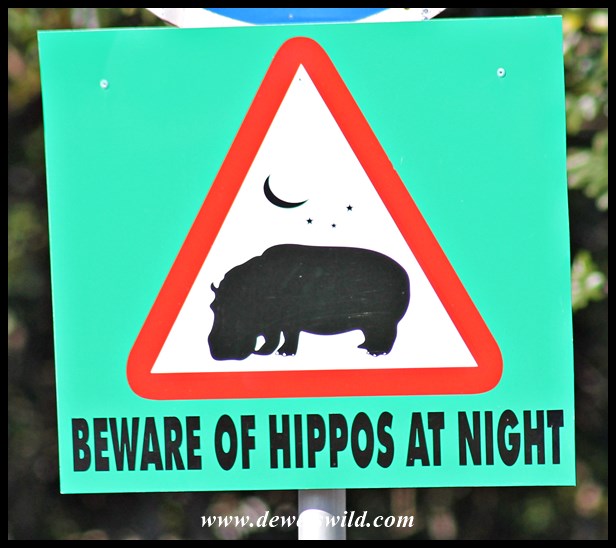
The centre’s beautiful gardens are a magnet for other wildlife, and we always get a kick from the humorous signs (to us, anyway).
")
")
")
")
")
")
")
Saint Lucia is a unique town, located on a wedge of land at the mouth of Lake St. Lucia, between the lake and the Indian Ocean, and entirely surrounded by the iSimangaliso Wetland Park. All kinds of wildlife roam the town, including hippopotamus and leopard. Right in town, a magnificent piece of coastal forest can be explored along the Gwalagwala Trail. A number of private operators offer guided tours of the area, and several launch-tours operate on the estuary. Two camping areas and a host of privately run establishments offers overnight accommodation, and the town has most of the facilities you’d expect (shops, restaurants, doctor, fuel station, boat club, picnic sites), making St. Lucia an excellent base for a bush-and-beach holiday.
It is hard to imagine a more peaceful mountain retreat than Kgaswane, especially so close to the maddening cities of Johannesburg and Pretoria.

Kgaswane sunrise, taken by Joubert!
Located in the western Magaliesberg mountain range, the Kgaswane Mountain Reserve forms an integral part of the Magaliesberg Protected Environment, an inspiring collaboration between private and state land owners and agencies to protect this beautiful ecosystem from exploitation. Proclaimed in 1967 as the Rustenburg Nature Reserve, incorporating the farm Rietvallei that once belonged to Paul Kruger (legendary president of the Zuid-Afrikaansche Republiek), Kgaswane today covers an area of 5,300 hectares and is managed by the North West Parks and Tourism Board.

The reserve is a popular hiking destination, with two overnight hikes; the Summit Route of 25km and the Baviaanskrans Route of 20km, each trail with two overnight hutted camps accommodating twelve hikers at a time. For day visitors, the 5km Peglerae Trail and 2km Vlei Ramble (which incorporates a bird-viewing hut overlooking the marshlands below the main visitor centre) is an excellent introduction to Kgaswane’s varied topography and habitats, with wonderfully shaded picnic sites available at the visitor centre. While the road network may be limited, it is tarred and in good condition, allowing for easy game and bird-viewing from vehicles and mountain bikes. There’s three spectacular viewing points along the way into the mountains from the entrance gate. Joubert and I spent a night on one of the twenty-two spacious camping sites and found the ablution facilities well maintained and entirely adequate (just remember to bring your own bath and sink plugs). There are no powerpoints at the camping sites but each site has a braai (barbeque) stand and picnic table and there’s a communal freezer available in the scullery. Best of all, there’s little to no cellphone reception in the camping area so no telemarketers can interfere with your rest and relaxation! Accommodation is also available in a self-catering cottage and two rondavels that sleep a combined 14 people and a group camp that can house up to 50 people in dormitory-style.
")
")
")
")
")
")
The Magaliesberg dominates the scenery at Kgaswane with rocky ridges, stacked boulders and deep ravines. The vlei (marsh) on the plateau is the largest in the Magaliesberg, and an important catchment area.
")
")
")
")
")
")
")
")
")
The reserve hosts good, though skittish, populations of a variety of game animals; we encountered black-backed jackal, baboon, warthog, eland, red hartebeest, plains zebra, oribi, reedbuck, blesbok, impala, kudu and waterbuck. The reserve’s birdlife is even more diverse, with 320 species recorded, including a breeding colony of endangered Cape vultures. Kgaswane’s most prized residents are the herds of the magnificent and rare sable antelope. It was here in the Magaliesberg that these regal animals first came to the attention of the scientific community, thanks to explorer Major Sir William Cornwallis Harris, in the 1830’s. But unlike Harris, we were not lucky enough to find the sable on our first visit to Kgaswane. And that’s just one of the excuses we’ll use to visit again, soon…
")
")
")
")
")
")
")
")
")
")
")
")
Kgaswane Mountain Reserve lies on the outskirts of the city of Rustenburg, in the North West Province, an easy 3km from the R24 offramp on the N4 highway and 134km from our home in Pretoria.

Pretoria to Kgaswane
(map drawn with Google Maps)

Talk about South Africa’s most scenic natural attractions, and the Drakensberg mountain range is sure to feature in the conversation. The Kamberg is a distinctive mountain, reminiscent of a comb (“kam” in Afrikaans, “berg” meaning mountain), in the foothills of the Drakensberg. The Kamberg Nature Reserve was originally proclaimed in 1951, covering only 2,232 hectares. Today it forms an integral part of the uKhahlamba Drakensberg Park‘s expansive 243,000 hectares of protected mountain paradise, recognised by UNESCO as a World Heritage Site of natural and cultural significance. Grasslands predominate, though forested sections exist in the sheltered valleys and extensive reedbeds and wetlands can be found along the Mooi (“pretty”) River, which forms a focal point for the reserve.
")
")
")
")
")
")
")
")
")
")
")
")
")
")
")
Whatever your energy levels, there’s ample opportunities to enjoy the refreshing mountain air at Kamberg. The reserve is well known in fly-fishing circles, with the Mooi River and two dams stocked with (admittedly exotic) trout. There’s three small, but well maintained, picnic sites – one in a copse of trees at the gate, one on the banks of Eland Dam, and one next to the river. Of course there are several trails leading down into the valleys and up into the mountains that may be explored on foot or mountain bike. And there’s a jungle gym and swings to keep the younger generation entertained within shouting distance of the chalets up at the camp.
")
")
")

")
")
The tiny camp at Kamberg, managed by Ezemvelo KZN Wildlife, is heaven-on-earth to any weary city dweller searching for peace and quiet, as there’s only 5 two-bedded chalets and one six-sleeper cottage at the camp. Eight kilometers from the main resort, the rustic and isolated Stillerust (Afrikaans for “quiet rest”) Farm House provides accommodation for ten guests. There’s a very limited selection of cooldrinks and sweets on sale at reception, and guests should bring along all their own provisions, firewood included. Just behind the camp, at the reception office, is the Kamberg San Rock Art Interpretive Centre where educational films on the San rock art of the Drakensberg are shown and from where the guided walks to the Game Pass Shelter departs. It’s a three-hour round trip to the internationally renowned cave, where high quality San paintings that were instrumental in deciphering the meaning behind the images left by these hunter-gatherers on rock faces across Southern Africa, can be appreciated. Unfortunately the prevailing weather conditions kept us from visiting the cave on this trip, but that’s reason enough in itself to return soon! For guests staying longer, Kamberg is also an ideal base from which to explore other destinations in the Drakensberg, such as nearby Giant’s Castle, and Midlands attractions like Midmar Dam, Karkloof Conservancy, Umgeni Valley Nature Reserve and Queen Elizabeth Park.
")
")
")
")
During our visit, the local wildlife mostly remained well hidden in the long, flowing grasslands through the day, except for a water mongoose that flashed across the trail next to Erskine Dam, a troop of baboons that sauntered through the camp one afternoon and a distant herd of black wildebeest we saw on the plains near Stillerust. At night however literally dozens of antelope; reedbuck, grey rhebuck and grey duiker, and hares and rabbits would come out to graze on the lawns between the chalets at the camp.
")
")
")
")
")
")
The Drakensberg is home to an amazingly diverse birdlife, with several rare and endemic species occurring at Kamberg. We were thrilled to see several pairs of grey crowned cranes in the wetlands, but absolutely overjoyed by our first ever sighting in the wild of the highly endangered wattled cranes, even if the breeding pair was quite far off in the distance and our photograph nothing more than proof of the sighting 😉
")
")
")
")
")
")
")
")
")
")
")
")
")
")
Speaking of cranes, we paid a quick visit to the Hlatikulu Crane Sanctuary on the nearby property of the Entabeni Education Centre where they take care of injured and orphaned blue, crowned and wattled cranes and do more than their share to preserve these special and endangered birds for South Africa’s future generations.
")
")
")
From Pretoria, it’s a drive of approximately 540km to Kamberg, following the N3 southwards to Mooi River. The road to the reserve turns off the R103 at Rosetta, between the Midlands towns of Mooi River and Howick. The 40km (30km tar and 10km gravel) stretch between Rosetta and Kamberg is a very scenic drive through green farmlands and the foothills that constitute the “Little ‘Berg”, and should not be rushed (the road is not in a good enough condition to travel on at speed in any case).
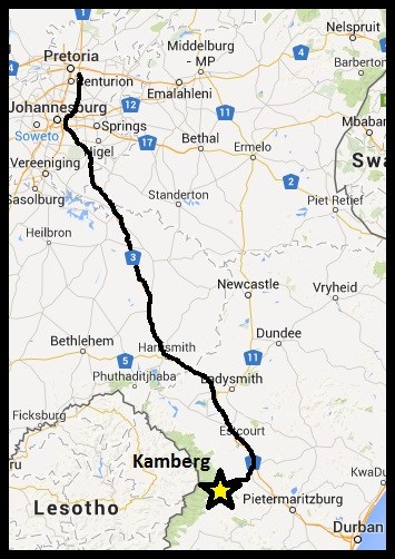
Pretoria to Kamberg (drawn from Google Maps)
Our first visit to Kamberg over a long weekend early in May 2015 opened only a tiny window onto the rich cultural and natural treasures protected there. We’ll be back for sure; there’s still so much to explore, experience and appreciate at this little known gem of “the ‘Berg”.
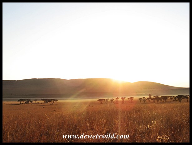
This morning, we awoke to beautifully clear skies here at Kamberg.
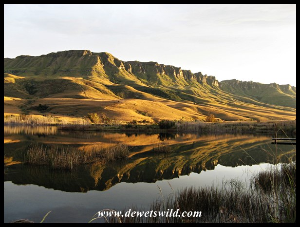
We also learned just how quickly and unpredictably the weather can change in the Drakensberg; within half-an-hour of this photo being taken it was completely overcast!
