

What better excuse to take another look at the 83 species of South African wildlife that we featured here at de Wets Wild in the past year than World Wildlife Day?

Beautiful African Leopard (Phalanta-butterfly)
")
Village Weaver (male)
")
Single-striped Grass Mouse

Violet-backed Starling
")
Rainbow Skink (male)
")
Gaudy Commodore (dry season form)
")
Brown Snake Eagle
")
Common Orange Tip (male)
")
Wood Sandpiper
")
Broad-bordered Grass Yellows
")
Amur Falcon
")
Common Hottentot Skipper (male)
")
Black-backed Puffback
 Terrapin")
Serrated Hinged Terrapin
")
Common Meadow White
")
Black-chested Snake Eagle
")
Small Orange Tip (male)
")
Buffy Pipit
")
Spotted Jokers congregating on rotting fallen fruit in Mpila

Purple Heron
")
Layman butterfly
")
Honey Bee on Cape Honeysuckle
")
White-throated Robin-Chat
")
African Common White
")
Ruff
")
Guinea-fowl Butterfly
 Comb Duck")
Knob-billed Duck female
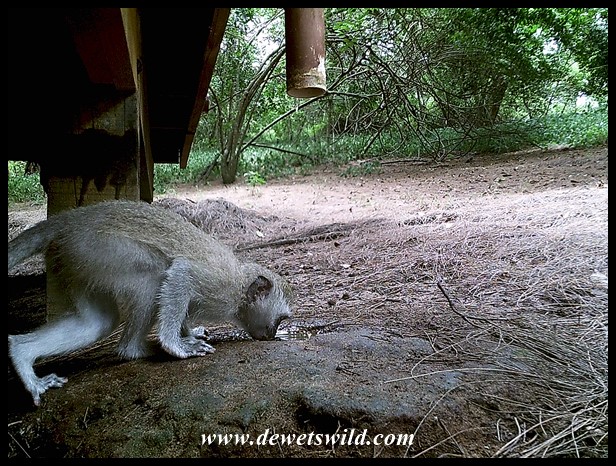
 African Wild Cat")
African Wild Cat
")
Male Lesser Masked Weaver
")
Geranium Bronze butterfly
")
Southern Black Tits
")
Swazi Lily
")
Brown-headed Parrot

Leprous Grasshopper
")
Cut-throat Finch male
 Purple Tip")
Mating Purple Tips
")
Red-billed Buffalo Weaver in Satara
")
Wattled Starling (male in breeding colours)
")
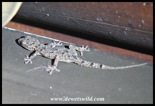
Turner’s Thick-toed Gecko
")
Black Stork

A huge bush cricket (Clonia wahlbergii) that shared our open-air shower at Mapungubwe National Park
")
Diederik Cuckoo
")
Common Diadem (male)
 Green-winged Pytilia")
Green-winged Pytilia (male)
 Butterfly")
African Migrant (Butterfly)
")
African Migrant (female form florella)
")
Little Bee-eater
 Senegal Lapwing")
Senegal Lapwing
")
Solifuge a.k.a. Sun Spider

Spotted Eagle Owl
")
Yellow-throated Plated Lizard
")
African Hawk Eagle

Free-tailed Bats roosting beneath the thatch at Mooiplaas’ ablutions
")
Lesser Striped Swallow
")
Sycomore Fig
")
Long-tailed Paradise Whydah
")
Male Red-backed Shrike (photo by Joubert)
")
Tree Creeper Scorpion
")
Green, or Red-billed, Wood-hoopoe

Variable Skink
")
Black-crowned Tchagra
")
Black-winged Stilt

Dung beetles
 Swift")
Little Swift reinforcing a nest
")
Spectacled Weaver
")
Patrician Blue
")
African Harrier Hawk
")
Common Dotted Border
 Giant Plated Lizard")
Giant Plated Lizards
")
Matabele Ants
")
Ashy Flycatcher
")
Brown-crowned Tchagra
")
Forest Beauty
")
Fulvous Whistling Duck (photo by Joubert)
")
Red-faced Mousebird

Guttural Toad
")
Squacco Heron
")
Little Sparrowhawk
")
Brown Hyena at the junction of Thuthlwa and Tlou drives in Pilanesberg
")
Thick-billed Weaver
")
Greater Red Musk Shrew
")
Ghost Crabs
")
Crowned Eagle (captive)


")
")
")
")
")
")
")
")
")
")
")
")
")
")
")
")
")
")
")

")
")
")
")
")


")
")
")
")
")
")

")
")
")
")
")
")
")
")
")
")
")
")
")
")
")
")
")
")
")
")
")
")
")
")
")
")
")
")
")
")
")
")
")
")
")
")
")
")
")
")
")


")
")
")
")
")
")
")
")
")
")
")
")
")
")
")
")

")
")
")
")
")
")
")
")
")
")
")
")
")
")
")
")
")
")
")

")
")
")
")
")
")
")
")
")
")
")
")
")
")
")
")
")
")
")
")
")
")
")
")
")
")
")
")
")
")
")
")
")
")
")

")
")
")
")
")
")
")
")
")
")
")
")

")
")
")

")
")
")
")
")
")
")
")
")
")
")
")
")
")
")
")
")
")
")
")
")

")
")
")
")
")
")
")
")
")
")
")
")
")
")

")
")
")
")
")
")
")
")
")
")
")
")
")
")
")
")
")
")
")
")
")
")
")
")
")
")
")
")
")
")
")
")
")
")
")
")
")
")
")
")
")
")
")
")
")
")
")
")
")
")
")
")
")
")
")
")
")
")
")
")
")
")
")
")
")
")
")
")
")
")
")
")
")
")
")
")
")
")
")
")
")
")
")
")
")
")
")
")
")
")
")
")
")
")
")
")
")
")
")
")
")
")
")
")
")
")
")
")
")
")
")
")
")
")
")
")
")
")
")
")
")
")
")
")
")
")
")
")
")
")
")
")
")
")
")
")
")
")

")
")
")
")
")
")
")
")
")
")
")
")
")
")

")
")
")
")
")
")
")
")
")
")
")
")
")
")
")
")
")
")
")
")
")
")
")
")
")
