Tag Archives: view sites

Camdeboo National Park

In 1975 the Southern African Nature Foundation (today WWF-SA) established the 165km² Karoo Nature Reserve virtually all around the historic town of Graaff-Reinet. It was only in 2005 that the Karoo Nature Reserve was transferred to the stewardship of South African National Parks, and officially proclaimed as the Camdeboo National Park. Additional land was incorporated into the new Park, enlarging it to 194km². Some parts of the reserve consists of inspiring mountain topography, and yet others of wide open arid plains. The Nqweba Dam, previously known as the Van Rhyneveld’s Pass Dam and built in the early 1920’s, occupies a large section of the Park (up to 1000 hectares when full). The vegetation of the Park is a mix of Karoo scrub, grasslands, thorn savannas and succulent thickets, consisting of over 330 species.

Camdeboo National Park’s most celebrated natural feature, and a declared scenic national monument, is the Valley of Desolation, an awesome cleft over 100m deep, bordered by imposing pillars of stone and cut by natural forces over a period of 240-million years into the side of the mountain looming over Graaff-Reinet. A tarred road leads to the toposcope and viewpoints right at the top, where visitors have an opportunity to enjoy the magnificent vistas over the expansive Great Karoo and the small frontier town situated in an oxbow bend of the Sundays River below.

The Karoo Nature Reserve and later Camdeboo National Park was stocked with several large game animals that used to occur here historically, and today Cape Buffalo and Cape Mountain Zebra count among the 43 kinds of mammals that can be seen here. All told, there’s no less than 225 kinds of birds, 34 reptile species and 8 varieties of frogs and toads that has been recorded within the Park’s borders.

Overnight guests have a choice between the four basic two-bed safari tents at the Lakeview Tented Camp, which make use of a communal ablution block, kitchen and lounge, or the Nqweba Campsite which has fifteen sites for caravans and tents (each with a braai stand (barbeque) picnic table and electric point). There’s a limited network of gravel game-viewing roads available to sedans, a few more 4×4 trails, hiking trails, fishing and other watersports on the Nqweba Dam, a bird-watching hide (unfortunately really only of use when the dam is full), and rustic picnic sites. Graaff-Reinet has shops, restaurants, fuel stations and more.

Camdeboo National Park was the final stop on our December 2017 holiday tour through eight of South Africa’s national parks. The easiest access to Camdeboo’s Nqweba Campsite, Lakeview Tented Camp and the main game-viewing area is from the gate on the N9, just a few kilometres north of Graaff-Reinet, while the gate to the Valley of Desolation lies on the R63 to Murraysburg.

Mountain Zebra National Park

Historically, the Cape Mountain Zebra occurred widely in the mountainous areas of what today is South Africa’s Eastern, Western and Northern Cape Provinces. With the settlement of Europeans in these areas, and the consequent increase in competition for grazing with their livestock as well as uncontrolled hunting, the numbers of the zebras started plummeting. With their plight finally brought to public awareness, the National Parks Board (today SANParks) proclaimed the farm Babylons Toren in the Cradock district the Mountain Zebra National Park in 1937. At 1,432 hectares in extent, the newly established Park was hopelessly too small, and the founding herd of 5 stallions and 1 mare entirely inadequate to save the species from certain doom, and by 1950 the world population of Cape Mountain Zebra had dwindled to only 91 animals, of which only 2 were in the national park that carried their name. That same year a local farmer donated 11 zebras to the park, but it was only in 1964 that the Park was expanded to 6,536 hectares with the addition of neighbouring properties. This proved very much to the zebras’ liking, and by 1969 the Park’s herd stood at 98 head and by 1978 had grown to 200. Today, the Mountain Zebra National Park protects around 500 of these beautiful animals, and several hundred more have been reintroduced to areas in their historic distribution range.

The Mountain Zebra National Park lies at the transitional zone between the arid western Karoo-scrublands and the moister, eastern grasslands, and protects a wide variety of habitats and landscapes within its borders. Given its amazing topographical diversity it should come as no surprise that over 700 plant species occur in the Park. With the future of the Cape Mountain Zebra secured, the focus of the Park could be shifted to biodiversity conservation, and with the help of wildlife artist David Shepherd and several corporate sponsors, enough funds were collected to enlarge the Park to over 28,000 hectares, which allowed the introduction of several large game species – notably lion, cheetah, buffalo and black rhino – to their former haunts.

Sharing the Mountain Zebra National Park with its most celebrated inhabitants is 65 other kinds of mammals…

… and to date 257 bird species have been recorded in the Park.

There’s also a multitude of smaller, less noticeable animals in the Park, including 45 kinds of reptiles, 10 species of frogs, and giant 4m long earthworms!

In recent years, Mountain Zebra has become one of South Africa’s most popular national parks, and recently the number of accommodation units at the Park’s rest camp (which also boasts a small shop, restaurant and swimming pool) had to be substantially increased to cater for the demand. Doornhoek Guest House is a historic homestead restored to its former glory and now converted to luxurious overnight accommodation in a secluded corner of the Wilgerboom River valley. There’s also a terrific camping site, two picnic sites, an extensive network of game-viewing roads, three 4×4 trails, a guided hiking trail and guided game drives available to visitors. A unique attraction at Mountain Zebra is the “cheetah tracking” where guests accompany researchers and rangers to find radio-collared cheetahs in their natural habitat.

Mountain Zebra National Park was the eighth and penultimate stop on our December 2017 tour through eight of South Africa’s national parks. It is located just outside the small town of Cradock, on the R61-road to Graaff-Reinet.

Addo Elephant National Park

By the early 1900’s the Eastern Cape’s wildlife was being exterminated at an alarming rate. The last lions and black rhinos in the region did not see the arrival of the year 1900, and only about 140 African Elephants remained around the Addo district, which was rapidly developing into an important agricultural area, leading to conflict with the newly established farmers. The government’s decision to intervene was not good news for the elephants. In 1919 they appointed Major P.J. Pretorius to destroy the elephants, and by 1920 he had killed 114 of them and caught 2 for a circus. Only 16 elephants remained when public sentiment swung in their favour and the wanton killing ended, and when the Addo Elephant National Park was proclaimed in 1931, only 11 elephants were left. It wasn’t until 1954 when an area of 2,270 hectares was surrounded by an elephant proof fence that the future of the Addo elephants finally looked secure. Along with the elephants, the last free-roaming herds of African (Cape) Buffalo that occurred in the then Cape Province, as well as the unique and endemic Flighless Dung Beetle, finally found a secure refuge. In subsequent years the Park’s area was expanded and species that fell into local extinction through the barrel of a gun were reintroduced.

With the Addo elephants now finally living in a safe refuge, the focus at Addo Elephant National Park is no longer on saving a single species. Today, the park’s management is concerned with the protection of the enormous diversity of landscapes, flora and fauna encompassed within its boundaries, which covers an expansive area of over 178,000 hectares stretching from beyond and across the Zuurberg range to the coastal forests and dune fields of Alexandria. The Park protects portions of no less than five of South Africa’s seven distinct terrestrial biomes, these being subtropical thicket, fynbos, forest, grassland and Nama-Karoo, not to mention the portion of marine environment protected around Algoa Bay’s St. Croix and Bird islands which is important breeding sites for endangered seabirds. Addo is the only National Park in South Africa that can claim to protect the “Big Seven” –  Elephant, Lion, Black Rhino, Buffalo, Leopard, Great White Shark, and Southern Right Whale.

Addo Elephant National Park protects a total of 95 mammals species, including all the members of the famed “Big Five“.

The Park also boasts a list of 417 bird species!

And if that isn’t enough, visitors also have a chance of spotting any of the more than 50 reptile species or 20 kinds of frogs and toads that call Addo Elephant National Park home. The Park’s most famous invertebrate inhabitant undoubtedly is the Flightless Dung Beetle (Circellium bacchus), this being only one of 5 places they are still found. These interesting insects make use of elephant, rhino, buffalo and kudu dung as food, either for themselves or rolled into brood balls in which they lay a single egg before burying it in soft sand and on which the larvae then feeds when it hatches.

The Addo Main Camp is the Addo Elephant National Park’s first and biggest tourist facility. Camping and a wide variety of accommodation (as well as a swimming pool) is available to overnight guests. There are picnic sites for day visitors, an underground hide overlooking a waterhole frequented by all the Park’s animals and floodlit at night (we even saw a brown hyena there when we visited in December), a birdwatching hide overlooking a small artificial wetland, a self-guided discovery trail, guided drives and horse rides, a fuel station, restaurant, shop and excellent interpretive centre where young and old can learn more about the Park and its inhabitants. Elsewhere in the Park guests can overnight at the luxury, full service and privately-run Gorah, Riverbend and Kuzuko-lodges, or in one of the Park’s own camps at Nyathi, Matyholweni, Kabouga Cottage, Mvubu Campsite, Narina Bushcamp, Langebos and Msintsi. Between the Main Camp and Matyholweni guests have access to an extensive and well-maintained network of all-weather game viewing roads, while other areas of the Park can be explored along hiking trails or 4×4 trails.

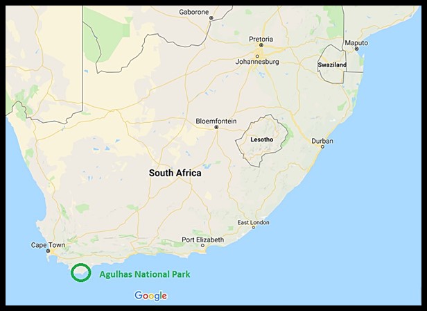
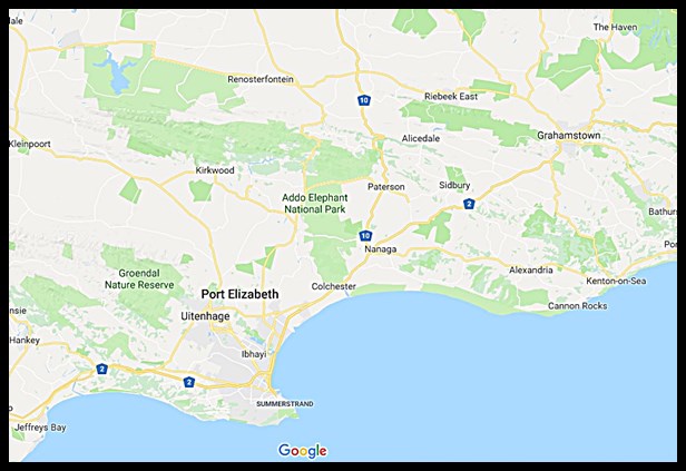
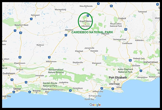
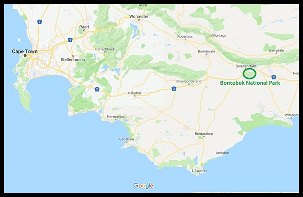
We spent three nights camping at the Addo Main Camp during our December 2017 holidays at eight of South Africa’s National Parks. The easiest way to reach the Park is along the N2 highway from Port Elizabeth, turning off to the gate at Matyholweni just before you reach the small town of Colchester on the bank of the Sundays River, about 45km from PE’s airport.

Tsitsikamma (Garden Route National Park)

When it was proclaimed in 1964, Tsitsikamma was the first marine national park in Africa. Since then it was progressively enlarged as more areas on land and sea was added to the Park, and by the time it was incorporated into the Garden Route National Park alongside Wilderness National Park, Knysna National Lake Area, and extensive tracts of state forests in between in 2009, the Tsitsikamma section covered an 80km stretch of coastline, extending on average 5km out to sea.

The name “Tsitsikamma” is a Khoekhoen word meaning “place of much water”, which is very apt as the region receives on average around 1,200mm of rain annually. This is a rugged but exceptionally beautiful area, with forested slopes, shear cliffs tumbling into the sea, deep ravines cut into the mountains by dark rivers over millennia, and enormous waves pounding unrelentingly onto the rocky shore.

The easy trail leading to the suspension bridges at the river mouth, about a kilometre from Storms River Mouth Rest Camp, the Tsitsikamma’s main tourst facility, really gives the visitor an excellent introduction to the Tsitsikamma-area; bringing you into contact with the beach, ocean, forest and river, and many of the creatures that find a home there.

Notably, Tsitsikamma’s list of recorded mammals is dominated by marine animals rather than the large terrestrial game species normally associated with a national park in Africa. That being said, visitors should count themselves lucky to see one of the seven whale or five dolphin species that ply these waters – we were fortunate to see a pod of Indian Ocean Bottlenose Dolphins in the surf and a handful of Humpback Whales breaching far into the sea. On land however the Chacma Baboons and Rock Dassies are ubiquitous inhabitants of the camp. And with almost 300 bird species recorded, many of which closely associated with the ocean and rocky beaches, the Tsitsikamma section is a birdwatcher’s delight. Most of the Garden Route National Park’s 25 species of snakes are seldomly seen, so we were thrilled to witness an altercation between a deadly venomous Boomslang and Southern Boubou while walking around one morning.

Walking around after dark, and seeing the healthy population of frogs and toads at Storms River Mouth, we realised how grossly inadequate our old guidebook on South Africa’s amphibians was to identify the 24 species that’s been recorded in the Garden Route National Park. We remedied that soon after we got back home!

As already mentioned, Storms River Mouth Rest Camp is the Tsitsikamma section’s main visitors facility and understandably one of the Garden Route’s top attractions. Here, wedged between mountain and sea, overnight visitors have a choice of spectacularly located accommodation and camping sites, serviced by a restaurant and shop that stocks basic food items and curios. There are picnic sites for day visitors and a small swimming beach. Guided boat tours and more adventurous activities up the Storms River gorge can be undertaken daily. Unique snorkeling and scuba trails allow visitors a glimpse into the underwater world of the Tsitsikamma, and on land several walking trails lead deep into the forest. At the eastern side of the Tsitsikamma section lies the more rustic Nature’s Valley Rest Camp, just outside the small holiday town of the same name. The renowned Otter Trail, covering a distance of almost 50km between Storms River Mouth and Nature’s Valley over 5 days, is rated as one of the best and most scenic hiking routes on the planet.

Storms River Mouth was the sixth destination on our December itinerary through eight of South Africa’s national parks. It is easily accessible along a good tarred road that turns off the N2 highway between Plettenberg Bay and Port Elizabeth.

Diepwalle (Garden Route National Park)

Originally, most of South Africa’s Garden Route between the mountains and the sea was covered by dense forests. Unfortunately these forests have been exploited on an industrial scale for wood and ivory since the 1760’s and the town of Knysna owns its existence to the lucrative trade that required access to a harbour for exporting. At various times attempts were made to protect pockets of forest from harvesting, but it is not until the 1880s, when a professional forester was appointed as superintendent by the colonial government, that any real effort went into the protection and sustainable use of what remained. Today only about a third of the indigenous forests remain, with a large proportion of it being protected in the Garden Route National Park, proclaimed in 2009 when several state forests were amalgamated with the Wilderness and Tsitsikamma National Parks and the Knysna National Lake Area.

North of Knysna, the Diepwalle State Forest was one of those pockets of forest afforded protection. One of the main attractions here is the enormous King Edward VII-tree, an Outeniqua Yellowwood tree estimated to be over 600 years old, towering almost 40m above the forest floor and so named by a group of British officials who were entertained to a picnic here in 1924. Diepwalle is also known to be part of the range of the last few remaining Knysna Elephants. In the 1880s it was estimated that between 400 and 600 elephants still roamed the Garden Route, yet today, a little over 100 years later, there may be only one lone cow remaining (even elephant researchers and park staff differ on exactly how many are left). Unless they are exceptionally lucky, the only contact visitors are likely to have with a Knysna Elephant is not along the Elephant Walk trail through the forest, but rather with the skeleton of one that is on display at the Forest Legends Museum at Diepwalle.

Diepwalle is easily accessible from Knysna, a short drive along the gravel R339 (Prince Albert’s Pass) leading to Uniondale. We spent a morning in the area while on our December holidays visiting eight of South Africa’s national parks. Guests can stay a night or two here on the unique camping decks set among the trees in the deep forest shade. Apart from the fascinating museum, there’s also picnic sites and a community-run tea garden serving delicious treats.


Wilderness (Garden Route National Park)

South Africa’s Garden Route is a 300km stretch of diverse and exceptionally scenic coastline between Mossel Bay in the west and the Storms River in the east, sandwiched between the Outeniqua and Tsitsikamma mountains and the Indian Ocean. The process of protecting the Garden Route from exploitation and human encroachment has been a long one, and is still ongoing. From the 1960’s various small pieces of the area east of the small holiday town of Wilderness received formal protection, culminating in these being amalgamated into the newly proclaimed Wilderness National Park in 1987 and the years thereafter. In March 2009, the erstwhile Wilderness National Park became an integral part of the expanded Garden Route National Park (covering a total of over 1,500km²), when it was joined with the Knysna National Lake Area and Tsitsikamma National Park through the proclamation of enormous tracts of state-owned land joining them.

The Wilderness section of the Garden Route National Park is centered on South Africa’s very own “Lakes District”. The original area encompassed by the Park straddles six lakes (Groenvlei, Bo-Langvlei, Langvlei, Rondevlei, Swartvlei and Island Lake), the Wilderness Lagoon, Serpentine and Touw Rivers, indigenous forests, and both rocky and sandy beaches along the coastline.

Before the Wilderness National Park was proclaimed, the area where the Garden Route National Park’s Ebb-and-Flow Rest Camp is situated today was the Ebb-and-Flow Nature Reserve (administered by the George municipality and today Ebb-and-Flow North) and the private Siesta Caravan Park (today Ebb-and-Flow South).

Birdwatchers and photographers are in for a treat when visiting any of the three hides next to the lakes in the Wilderness section of the Garden Route National Parks. We had time to visit two of them in December – Malachite (on Langvlei) and Rondevlei, and could easily have spent all day at either.

Given the amazing diversity of habitats in the park, it is no surprise that the Wilderness section of the Garden Route National Park abounds with a wide variety of birdspecies, and while the area doesn’t support much in the way of large mammals apart from shy bushbuck, bushpigs and very seldomly seen leopards, it does give visitors the opportunity to walk around unhindered looking for the smaller fry.

Ebb-and-Flow Rest Camp is the Wilderness section’s main visitor node. Here there are accommodation and two expansive camping areas for overnight guests, a newly opened picnic area for day visitors, and canoes for hire to explore the Touw and Serpentine Rivers. A network of walking trails of varying length traverse the area, many of them starting at or near Ebb-and-Flow. The Park also has several beaches for sun-seekers and bathers. Privately-run accommodation establishments and camping sites, shops, restaurants, fuel stations and more are available in the nearby towns of Wilderness and Sedgefield.

The Wilderness section of the Garden Route National Park is easily accessible along the N2 highway running from Cape Town to Port Elizabeth, and is just a few minutes’ drive from the airport at George. We recently spent three nights camping in the lovely Ebb-and-Flow North camp, the fifth stop on our 2017 summer holidays in eight of South Africa’s national parks.

Bontebok National Park

The Bontebok, a colourful antelope endemic to the Western Cape of South Africa, roamed the area between the present towns of Caledon and Mossel Bay in their thousands at the time the Dutch first established their trading post at Table Bay in 1652. Uncontrolled hunting however quickly led to the population crashing, and despite conservation minded farmers’ best efforts only 121 Bontebok remained by 1927. In 1931, the precarious situation of the Bontebok moved the National Parks Board to establish the Bontebok National Park on an area of 722 hectares outside Bredasdorp, with a founding population of just 17 animals. This area however was poorly chosen, and the animals suffered from disease and poor grazing. It was decided to find an alternative location for the Park, and in 1960 the present site on the outskirts of Swellendam was proclaimed as the Bontebok National Park with a population of 61 of its most precious charges that survived the translocation. Covering 3,900 hectares with little prospect of further expansion due to it being surrounded by the town and croplands, the Bontebok National Park is South Africa’s smallest National Park. Here the Bontebok thrived, and when the Park reached its carrying capacity of about 250 Bontebok, animals could be donated and sold for reintroduction to other parts of their historic range. More about the Bontebok in our next post.

The recorded history of the area that today encompasses the Bontebok National Park dates back much further than that though. By the time the Dutch settled in the Cape, this area was already inhabited by the Hessequa, a Khoekhoen tribe, that moved into the area about 2000 years earlier and was very successful farmers with healthy herds of especially cattle and sheep. The Hessequa clans lived in settlements known as “kraals”, under the leadership of “captains” controlled by a powerful chief. Lang Elsie, who lived between 1734 and 1800, was notable for being a female captain and her kraal was located on the banks of the Breede River, near the site now occupied by the Park’s tourist accommodation. Today, the remains of Lang Elsie’s small stone house can be seen a short walk away from the rest camp that carries her name, while efforts are being made to restore the open site where her followers lived in traditional huts made of sedge thatch. The Dutch started trading with the Hessequa in the 1660’s, and as the years progressed more and more European settlers moved into the area, leading to the establishment of Swellendam in 1746. By the end of the 18th century, Western “civilisation” had brought an end to the traditional lifestyle of the Hessequa Khoekhoen. Those that survived waves of disease epidemics were forced into life on farms or on mission stations.

The Bontebok National Park is largely flat, ranging in altitude between 60 and 200m above sea level. In the south, the broad and slow Breede River is a permanent feature. To the north, the Langeberg mountain range lies outside the Park. Most of the Park’s vegetation is classified as fynbos, mostly low growing, with thickets of various tree species lining the river. About 470 indigenous plant species have been recorded in the Park; with most of the surrounding areas being intensively farmed this pocket of natural vegetation is extremely valuable. Unfortunately the alien invasive water hyacinth is proving difficult to eradicate from the river.

While the Bontebok remains the Park’s star attraction among the 36 kinds of mammals that find refuge here, there’s several other kinds of non-threatening large game animals that may be encountered, and over 200 bird species have been recorded. There’s also 28 kinds of reptiles, but apart from the ubiquitous Angulate Tortoises most are rarely seen. Ten species of amphibians and twelve species of fish (6 of which is exotic) also occur at Bontebok National Park.

Overnight visitors to Bontebok National Park’s Lang Elsie’s Kraal Rest Camp have the option of camping or staying in one of the 14 comfortable chalets with either 1 or 2 bedrooms. Day visitors are well taken care of at the picnic area at Die Stroom next to the Breede River. Visitors are welcome to walk and cycle through the Park, with several well-marked trails at their disposal, or swim, canoe and fish in the river. There is also a limited network of gravel game-viewing roads, for the most part easily negotiable in a sedan. Shops, restaurants, fuel and other services are available in Swelledam, just a few minutes from the Park’s entrance gate on the N2 highway.

Bontebok National Park is located just outside the town of Swellendam, with the entrance gate less than a kilometre from the N2 highway leading to Cape Town, about 240km away. Bontebok was the fourth destination on our December holiday tour of eight of South Africa’s national parks. Unseasonably wet weather severely curtailed our explorations of this Park during the two days we had available there, so we will just have to return for more!


Agulhas National Park

Fifteenth century Portuguese seafarers named Cape Agulhas when they found that magnetic compass needles pointed precisely true north here (“agulhas” being Portuguese for “needles”). It is also the southern-most point of the African mainland, where the Atlantic and Indian Oceans meet, and has been inhabited by humans for over a million years with several sites of archaeological interest. The Agulhas Plain also has an incredible biodiversity and it was realised that what remained of it was worthy of protection, leading to the proclamation of the Agulhas National Park in 1999. Today the park covers almost 230km².

This is one of the world’s most treacherous coastlines. Since 1552, at least 125 ships met their fate around Cape Agulhas. For this reason the lighthouse at Cape Agulhas was commissioned in 1849, and is the second oldest of the 56 working lighthouses along our coast. It was designed as a replica of the Pharos of Alexandria, one of the seven wonders of the ancient world, and at night its beam can be seen up to 60km offshore. One of the most easily seen wrecks is that of the Meishu Maru, a Japanese fishing vessel with a cargo of 240t of tuna, that ran aground in 1982, happily without any loss among the 17 crew members. Today, a fascinating museum and information centre is housed inside the lighthouse.

The vegetation of the Agulhas National Park consists mainly of fynbos, with an estimated 2,000 plant species finding protection within its borders, many of which are rare and occur nowhere else on earth. The vegetation doesn’t grow very tall here due to the extremely windy conditions that prevail throughout the year. The area is rather flat and featureless, with rocky and sandy beaches alternating and stretching for many kilometers. And the sunsets from the main camp, as the sun dips into the Atlantic Ocean (the camp lies west of the southernmost tip of Africa) is a sight to behold!

The Park is still being developed, and as such does not yet contain large terrestrial mammals in any significant numbers. Most of the mammal species that occur here are either marine or small and rarely seen. The Agulhas National Park is however a prime birding spot, both for land and sea birds.

Guests can overnight in the main rest camp, which consists of one or two bedroom cottages and the luxury Lagoon House, built right on the rocks at the ocean’s edge. A few historic farm houses spread throughout the inland portions of the Park has also been renovated to accommodate guests. An extensive network of walking trails have been laid on around the main camp. All modern services and amenities associated with small holiday towns can be found in nearby L’Agulhas and Struisbaai. The nearest big town is Bredasdorp, 35km to the north.

The Agulhas National Park is located about 250km southeast of Cape Town, with the main rest camp a short drive from the small holiday town of L’Agulhas. It was the third destination on our December holiday tour of eight of our country’s national parks.


Boulders Beach and Penguin Colony (Table Mountain National Park)

Boulders, a sheltered cove in the naval town of Simon’s Town, comprises a few small bays and beaches protected by enormous granite rocks, 540-million years old, from the pounding surf of the Atlantic Ocean in False Bay. It is one of the most popular attractions in the Table Mountain National Park.

In 1982, two pairs of African Penguins took the unusual step of settling and breeding on the mainland here at Boulders. Today, the colony has grown to number over 2,000 birds and offers probably the most accessible views of penguins to be had anywhere in the world. Visitors are urged not to get too close to the penguins and not to try and touch them, as they’ll not hesitate to nip a finger or nose with their razor sharp beaks if they feel threatened.

While pride of place obviously goes the the penguins, there’s a multitude of other wildlife – birds and mammals especially – that find a safe refuge at Boulders.

Wheelchair-friendly boardwalks erected at Foxy Beach allows visitors to get up close to the penguins, while swimming and sunbathing is popular at Boulders Beach. The two beaches are connected by a lovely walkway through indigenous bush known as Willis’ Walk. There is a curio shop at the visitor centre, and several restaurants, cafes and coffee shops nearby in Simon’s Town.

Boulders Beach and Penguin Colony is located in Simon’s Town, base of the South African navy south of Cape Town. Parking is available in Seaforth Road and Bellevue Road, both of which turn off the main Milner’s Point Road (M4) leading through town.

Cape of Good Hope (Table Mountain National Park)

Archaeological investigations indicate that the Cape Peninsula, the mountainous promontory that stretches for over 50km from Table Mountain in the north to Cape Point in the south at Africa’s south-westernmost extremity, has been inhabited intermittently by humans since the Early Stone Age, roughly 600,000 years ago. First described as the “Cape of Storms” by Portuguese explorer Bartolomeu Dias, the first known European to navigate around the southern tip of Africa in March 1488, and then given the moniker “Cape of Good Hope” by King João II of Portugal as Dias’s “discovery” opened the possibility of an oceanic trade route to India and the Far East, the most flattering description for this stretch of rugged coastline came from English Admiral Sir Francis Drake in 1580, when he referred to it as “a most stately thing and the fairest cape we saw in the whole circumference of the earth“. Today, two “padrãos” – replicas of the limestone pillars erected by Portuguese explorers on their voyages to signify Portuguese and Christian sovereignty and erected in 1965, commemorate two of those erstwhile explorers: Dias and Vasco da Gama, the first to reach India from Europe around the African coast.

In 1939, the Cape of Good Hope Nature Reserve was established on the southern tip of the Cape Peninsula. In 1998, the reserve’s 7,750ha was incorporated into the Cape Peninsula National Park, which was renamed the Table Mountain National Park in 2004. The land area of the Park covers a total of almost 300km², with a further 975km² of the ocean protected in a marine reserve. Managing this National Park with Cape Town and its suburbs, a city of 3,7-million people, right on the doorstep must be a daunting task and with over 4-million visitors annually, the Table Mountain National Park is one of South Africa’s top tourist attractions.

Cape Point consists of dramatic sea cliffs, among the highest in the world, jutting into the Atlantic Ocean at the tip of the Peninsula. On a clear day the view from the top is nothing short of spectacular. The “Flying Dutchman” Funicular (named for Captain Hendrick van der Decken’s ghost ship still plying these waters in stormy seas) is available to take visitors up to the old lighthouse and viewpoints and back down, though there’s always the option of hiking the 800m distance.

Commonly described as Fynbos, the natural vegetation of the Table MountaIn National Park is an integral component of the Cape Floral Kingdom, which, with an amazing 9,004 plant species is the smallest of only 6 plant kingdoms recognized in the world and a UNESCO Natural World Heritage Site. There are over 2,285 indigenous flowering plant species on the Cape Peninsula – compare that to fewer than 1,500 species indigenous to the entire British Isles! Inside the Cape of Good Hope section of the Park alone, over 1,200 plant species have been identified.

The Cape Peninsula may be world renowned for its awesome scenery, but it is also home to a wide variety of birds (303 species on land and sea), mammals (58 terrestrial and 36 marine species) , reptiles (64 species), amphibians (17 species) and fish (including the Great White Shark), not to mention countless invertebrates.

Visitors may overnight inside the Cape of Good Hope section of the National Park at one of three cottages (Olifantsbos, Eland & Duiker) or on the Hoerikwaggo Cape of Good Hope Trail. An extensive network of tarred roads lead to several viewpoints and picnic sites, two of which have tidal pools as swimming in the sea at many of the beaches here is considered rather risky, while a restaurant and curio shops can be found at Cape Point.

We spent two nights at Eland Cottage at the Cape of Good Hope during our epic December holidays in eight of South Africa’s national parks.

The Cape of Good Hope section of the Table Mountain National Park lies to the south of the city of Cape Town, and can be approached either from the town of Kommetjie along the Atlantic seaboard (road M65), or through Simon’s Town on the False Bay coast (road M4 / M66).