Lower Sabie must be the most popular destination in the Kruger National Park. It is exceedingly hard to get a booking here if you don’t book a year in advance. In peak season, even just finding parking to visit the shop or restaurant can be a challenge, as visitors from all over the the southern sections of the Park flock to the camp. The camp’s location on the banks of the Sabie River, in an area of exceptionally high-quality grazing in the south-eastern corner of the Park, ensures that its surrounds is frequented by an astounding variety and number of herbivores and their attending predators, making for game-viewing heaven!

The Sabie River got its name from the Shangaan word “saba” meaning fear, probably due to the large number of enormous crocodiles that call the river home. The dam in front of the camp came about after the causeway across the river was built in 1987 (it had to be rebuilt higher after the floods in February 2000).
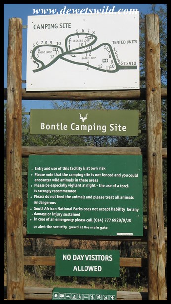
The first tourist accommodation at Lower Sabie was a 5-bedroom house converted from ranger Tom Duke’s quarters in 1930, but this was demolished again just two years later after becoming dilapidated. The only access to Lower Sabie was via Gomondwane from Crocodile Bridge until the road from Skukuza reached it in 1931. The next attempt at providing guest accommodation at Lower Sabie then commenced in 1936, when three buildings, built in a u-shape and each housing six bedrooms, were erected – these units are still used as accommodation to this day, but has been extensively renovated since. Over the years, more accommodation and a camping site was added to the camp, leading up to an extensive project to revamp and enlarge Lower Sabie in the early 2000’s. Today the camp provides overnight accommodation in 117 huts, bungalows, cottages and safari tents and has space for 34 caravans and tents in its camping area. Lower Sabie’s restaurant (Mugg & Bean), with its deck overlooking the Sabie River, is especially popular. The camp has a well stocked shop for groceries and curios, a fuel station, swimming pool for overnight guests and a day visitors picnic area near the gate. Along the river, in front of the bungalows south of the restaurant, lush lawns and deep shade provided by enormous trees is just the place to spend a lazy afternoon, surrounded by Lower Sabie’s prolific birdlife.
")
Lower Sabie’s restaurant sen from across the river
")
The deck at Lower Sabie’s restaurant
")
Lower Sabie restaurant
")
Lower Sabie shop
")
Lower Sabie swimming pool
")
Lower Sabie picnic area

Lower Sabie cottage 93, December 2015
")
Lower Sabie bungalows
")
Lower Sabie bungalows and gardens
")
Lower Sabie bungalows and gardens
")
Lower Sabie Tent 26, July 2015
")
Lower Sabie safari tents
")
Lower Sabie huts
")
Lower Sabie huts
")
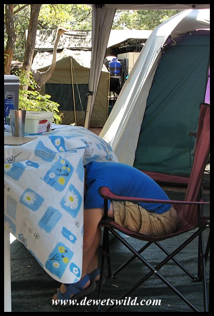
Lower Sabie camping area
")
Beauty in Lower Sabie
")
Well camouflaged agama
")
Cape Glossy Starling
")
Arrow-marked Babbler
")
Southern Masked Weaver
")
Spectacled Weaver
")
Blue waxbill
")
White-Browed Robin-Chat

Grey Go-away-bird hiding from the heat in a shady Lower Sabie tree
")
Elephants and impalas mingle on the bank of the Sabie
")
Crossing the Sabie
")
Elephant passing right in front of our cottage
")
Elephant next to the fence
")
A family of Greater Greater Cane-rat
")
Night time view from our tent’s deck
We can certainly recommend joining at least one of the guided activities on offer from Lower Sabie, as excellent sightings are almost guaranteed.
")
All aboard!
")
Night drive scorpion
")
The guides are expert at seeing chameleons in the spotlight
")
African wildcat seen on a night drive from Lower Sabie
")
Verreaux’s Eagle Owl
Sunset Dam is a brilliant spot just a kilometer from Lower Sabie, and as its name suggests is very popular with visitors whiling away the last minutes before they have to get back to camp in the evening. You can park your vehicle right on the water’s edge, allowing excellent photographic opportunities of hippos, crocodiles, wading birds and herds of game coming to quench their thirst.
")
Sunset Dam, in daylight
")
Hippo returning to the water
")
Yaaaawwwwwnnnnn!
")
Common sandpiper at Sunset Dam
")
Yellow-billed Stork at Sunset Dam
")
Guineafowl hoping for a morsel – don’t be tempted!
")
Wood sandpiper at Sunset Dam
")
This crocodile may seem fast asleep, but if anything ventures into the water he’ll be quick to react.
")
Lurking crocodile
")
Sunset Dam, at sunset…
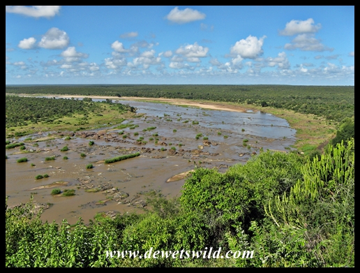
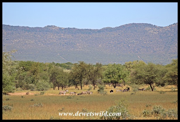
Heading north from Lower Sabie along the H10 tarred route to Tshokwane, you’ll encounter the first highlight of this route just minutes after leaving camp. The causeway across the Sabie River is a favourite spot for many visitors, who flock here to enjoy glorious sunsets and an abundance of game and bird species attracted to the water. The plains between Lower Sabie and Tshokwane is home to incredible herds of zebra and wildebeest at the end of winter, and is also an excellent place to look for reedbuck, one of the rarer antelope that occurs in Kruger. Of course, with so many herbivores roaming around it stands to reason that the predators are not far behind. If you, like us, enjoy your game viewing with as little other traffic as possible, try the gravel S29, S122 and S128 loops that turn off the main road as alternatives to explore this area. Two other beautiful places not to be missed is Mlondozi Picnic Spot, overlooking a large dam from Muntshe mountain, and Nkumbe Viewpoint, which offers an exceptional view over the open plains of Kruger.
")
H10 Causeway at Lower Sabie
")
H10 Causeway at Lower Sabie
")
Making waves!
")
Tigerfish in the Sabie River
")
Giant Kingfisher hunting from the bridge
")
Green-backed heron
")
White-crowned Lapwing on the bridge
")
Warthogs drinking from the Sabie
")
Hippo jaw on a Sabie sandbank
")
Lion love at Lower Sabie

Lion love at Lower Sabie
")
Warthog
")
Reedbuck are often seen between Lower Sabie and Tshokwane
")
Muntshe mountain seen from the north
")
Hyena on the S29 to Mlondozii
")
Elephant bull with Muntshe in the background
")
Mlondozi picnic spot
")
Mlondozi picnic spot
")
Mlondozi picnic spot
")
Zebra crossing a very wet road
")
Giraffe under heavy skies
")
African Rock Python just north of Muntshe Mountain
")
Black-bellied Bustard
")
Plains zebra
")
Pearl-spotted Owlet at Mlondozi
")
Giraffe, with Nkumbe in th background
")
Klipspringer ewe enjoying the drizzle
")
Klipspringer ram on Nkumbe
")
Wet waterbuck
")
Nkumbe viewpoint
")
Nkumbe viewpoint
")
Herd of wildebeest far below Nkumbe viewpoint
")
Waterbuck at the Mapilini stream just north of Nkumbe
")
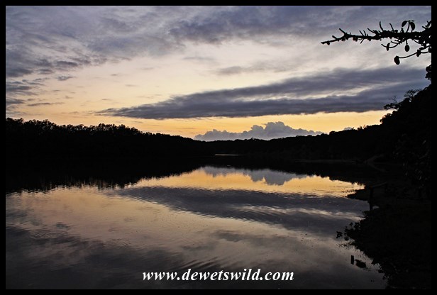
Lower Sabie sunset
The tarred H4-2 Gomondwane Road leading south to Crocodile Bridge is another very productive route for game viewing, though we personally prefer taking the gravel loops running roughly parallel to the main road (S28 Nhlowa Road, S82 Mativuhlungu Loop, S130 Gomondwane Loop and S137 past Duke’s waterhole) as these carry a little less vehicle traffic.
")
Lower Sabie sunrise
")
Scrub hares are often seen in the early morning
")
Kudu crossing the road
")
Passing close-by!
")
Leopard tortoise feeding on fresh shoots next to the road

African Green Pigeon
")
Plains zebra are plentiful along the roads south of Lower Sabie
")
Plains zebra are plentiful along the roads south of Lower Sabie
")
Kori bustard, one of the biggest flying birds on earth
")
Impalas are a regular sight around these parts
")
Side-striped Jackal
")
Spotted hyena mother
")
Excited young elephant
")
White rhinoceros
")
Landmark on the S130
")
Swainson’s Spurfowl
")
Warthog cooling off in the midday heat
")
Fight for dominance
")
Crested Francolin chick
")
Blue wildebeest
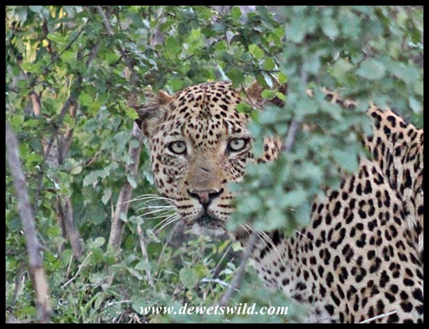
The H4-1 road between Lower Sabie and Skukuza carries more traffic than any other road in Kruger, and not without reason. There’s an excellent chance of seeing all the “big 5” game animals and so much more along this route, which follows the course of the Sabie River, on just one drive. The vegetation along the portion of this road nearer Lower Sabie is much more open than the stretch between Nkuhlu and Skukuza, making for even better game viewing. Keep your eyes open for lions and leopards at the rocks at the Lubyelubye stream crossing about 5km from Lower Sabie, as this is one of their most reliable haunts. Also, don’t miss the short S79 gravel loop that crosses the Nwatimhiri causeway, which is another favourite spot for feline predators. Nkuhlu Picnic Spot is a great place to get out, stretch the legs and have a bite to eat (though beware the monkeys and baboons that hang around here, as they will attempt to steal your picnic if they get even the slightest chance!). The gravel S30 Salitje Road along the northern bank of the river is a wonderful alternative route back to Lower Sabie.
")
Elephants on the move in the Sabie
")
Leopard lying in the bed of the Nwatimhiri near Skukuza in the Kruger Park
")
Buffalo crossing the H4-1
")
Nkuhlu Picnic Site
")
Arrow-marked babbler at Nkuhlu
")
Water Monitor at Nkuhlu
")
Saddle-billed Stork fishing at Nkuhlu
")
Elephant cow and calf
")
Common Duiker ewe
")
Brown-hooded Kingfisher
")
Baboon
")
Kudu bull
")
Lion greeting near Lubyelubye
")
Rocks at Lubyelubye
If all these photos did not convince you, allow us to reiterate: Lower Sabie IS game-viewing heaven! Remember to book early if you also want to enjoy all it has to offer.

")
")
")
")
")
")
")
")
")
")
")
")
")
")
")
")
")
")
")
")
")
")
")
")
")
")
")
")
")
")
")
")
")
")
")
")
")
")
")
")
")
")
")
")
")
")
")
")
")
")
")
")


")
")
")
")
")
")
")
")

")
")
")
")
")
")
")
")
")
")
")
")
")
")
")
")
")
")
")
")
")
")
")
")
")
")
")
")
")
")
")
")
")
")
")
")
")
")
")
")


")
")
")
")
")
")
")
")
")
")
")
")

")
")
")
")


")
")
")
")
")
")
")
")
")
")
")
")
")
")
")
")
")
")
")
")

")
")
")
")
")
")
")
")
")
")
")
")
")
")
")
")
")
")
")
")
")
")
")
")
")
")
")
")
")
")
")


")
")
")
")
")
")
")
")
")
")
")
")
")
")
")
")
")
")
")
")
")
")
")
")
")
")
")
")
")
")
")
")
")
")
")
")


")
")
")
")
")
")
")
")
")
")
")
")
")
")
")
")
")

")
")
")
")
")

")
")
")
")
")
")
")
")
")
")
")
")
")
")
")
