Category Archives: Kwazulu Natal Province

Our experiences in the reserves of Kwazulu-Natal, South Africa

Winter, or not, at Royal Natal

Early August is still considered winter in South Africa. In preparing for our latest trip to Royal Natal National Park, in the uKhahlamba Drakensberg Park and World Heritage Site, we had therefore anticipated snow, at least on the high peaks, and severely cold temperatures. Watching the weather forecasts in the days before our visit was a confusing affair. One private weather site was predicting extreme cold and gloomy weather, while the national weather service predicted glorious sunshine with temperatures in the mid 20’s. Not knowing what to expect, we packed for any eventuality.

The Women’s Day long weekend was only three days long, and so we decided to get an early start out of Pretoria. Through the Free State, the outside temperature remained around freezing. Imagine therefore our excitement seeing the temperature reading on the dashboard rise as we descended the Drakensberg Range into Kwazulu-Natal Province, with not a flake of snow to be seen anywhere! By the time we arrived at Rugged Glen, just to the east of the Royal Natal National Park‘s entrance, it was warm enough to start taking off some layers of clothing and soak in the sunshine. The South African Weather Service got it right this time!

Despite it being a long weekend, the campsite at Rugged Glen was devoid of people; perhaps the predictions of poor weather dissuaded many campers from venturing to “The ‘Berg” for a break. Whatever the case may have been, we didn’t complain about having only Rugged Glen’s diverse birdlife and a few nervous reedbuck to share our first mountain picnic with.

From Rugged Glen, which is also the base for the popular guided bridle trails that traverse these scenic hills, we headed to the Park’s gate, supported the crafters selling their wares and then drove the short distance to the Mahai Visitor Centre. Time for another picnic at one of the tables along the Mahai stream before making our way along, and a little beyond, the pretty and easy Cascades boardwalk, passing several dainty bushbuck ewes along the way while a herd of eland grazed high above us on the slope of Dooley Mountain (named after an Irish logger given a concession to cut wood here in the late 1800’s).

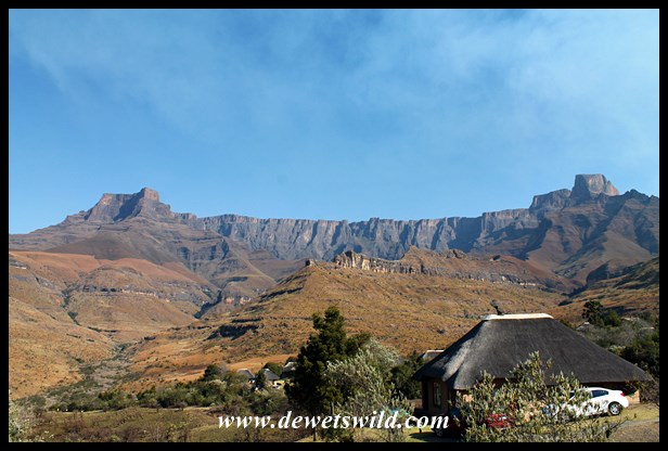
With our hiking boots now introduced to Royal Natal’s network of walking trails it was time to head to Thendele Camp and our accommodation for the two nights we’d be spending at the foot of the magnificent Amphitheatre formation, a basalt cliff-face almost 1000m high and 5000m wide. To the left of the Ampitheatre is the Eastern Buttress, 3011m above sea level, and to the right Sentinel peak soars to 3165m ASL. These majestic natural features absolutely dominates the scenery at Royal Natal, which together with Rugged Glen covers over 8000 hectares, and was the main reason for the Park’s proclamation in 1916. The “Royal” moniker was added to the reserve’s name after a visit by the British Royal family in 1947. The vegetation in the Park, more than 900 species strong, is mostly open grassland dotted with a few hardier trees and shrubs, with heathland on the summit and mountain forests in the sheltered valleys.

We found Thendele alive with bird song, and just below the huts a small group of mountain reedbuck were right at home. Despite the camp’s 29 units (offering between 2 and 6 beds each) being fully booked, it was a haven of peace and tranquility – just the way we like it. At 1580m above sea level, Thendele lies a lot lower than the peaks that tower above it.

Evening temperatures were admittedly a lot cooler, and our chalet’s lounge with its cosy fireplace was just the place to enjoy dark chocolate and a cup of coffee at the end of a wonderful day spent outdoors.
Royal Natal August 2015 (36)

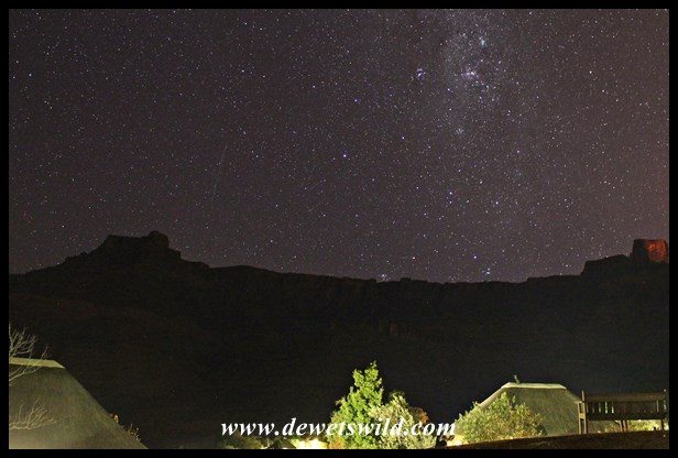
The early morning sun on Sunday bathed Thendele and the Amphitheatre in a glorious gold, inviting Joubert and I to walk around camp while Marilize prepared a hearty breakfast.

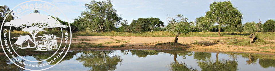
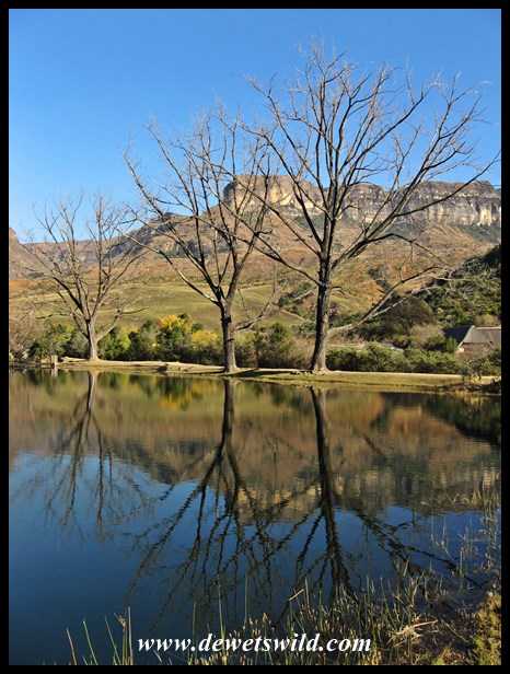
Our first destination this morning was the trout dam at Mahai, where the windstill conditions made for splendid reflections on the water’s surface and we found out just how easy it is to loose complete track of time while marveling at the spectacular scenery around us.

Royal Natal’s biggest attraction is the selection of well demarcated hiking trails traversing the area and excellent pocket guides and maps are available at the shops at Thendele and the Visitor Centre. One of the easier trails is Otto’s Walk, which starts at the Visitor Centre’s parking area and named after one of the reserve’s early Superintendents, Otto Zunckel. It follows the course of the Mahai stream through dense mountain forest for most of the way before returning along the main access road, a total distance of 3km. The pair of rare Mountain Wagtail we encountered at a pleasant spot next to the stream was a real highlight. Another particularly interesting walk is to the San Rock Art site in the Sigubudu Valley, accessible at a small fee and accompanied by a local guide.

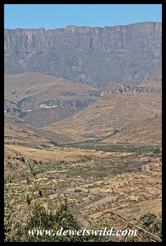
Along the main access road from the gate to the Visitor Centre there’s a viewpoint offering an absolutely unobscured view of the Amphitheatre and the wider Drakensberg range. With winter being the dry season, the Thukela River was barely flowing, with only a trickle evident among the rocks and pebbles in the river bed. There was also no sign of the Thukela Falls, which with a combined drop of almost 950m is the 2nd highest waterfall on the planet. One of the Park’s most popular trails follows the impressive gorge cut by the Thukela through the Drakensberg’s sandstone.

Royal Natal August 2015 (57)

We spent the afternoon relaxing around Thendele, enjoying an ice cream on the lawns outside the reception office and exploring the short forest walk behind the camp.

On our final morning, before heading back to Pretoria, we awoke to a Thendele cloaked in thick mist. And cold. Neither the Amphitheatre above nor the Thukela Valley below was to be seen. The wintry weather we had been dreading seemed to have set in just as we were about to depart. After spending two lovely days walking and picnicking in these beautiful mountains, we were immensely grateful for the blessing of good weather! And as we drove out the park that morning, we were already going through our diaries to see where we’d be fitting in our next visit to this magnificent mountain landscape.

The previous time we visited Royal Natal (April 2012), we traveled to the Park via the Oliviershoek Pass and found it such a pothole-ridden affair that we took a 100km detour to return via Van Rheenens Pass instead. This time we decided to give Oliviershoek (the R74) another try for the last 70km from Harrismith to the Park. The road is being rebuilt and by the time it is finished this should again be one of the country’s most enjoyable drives. For the moment, there’s a 6km stretch of one way traffic on which Stop / Go controls are operating, and a further 15km portion on a wide, smooth gravel detour, perfectly safe to travel in a sedan as long as you don’t try to drive too fast.

Route to Royal Natal

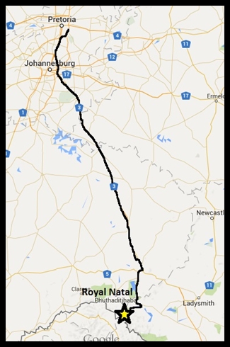
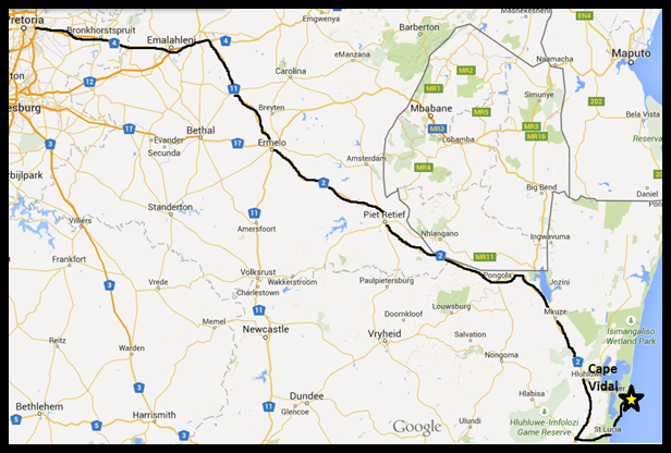
Pretoria to Royal Natal (drawn with Google Maps)

The Royal Natal National Park, Thendele Resort and Mahai and Rugged Glen Campsites are managed by Ezemvelo KZN Wildlife.

From Every Angle

We’ve shown you this exuberant baby white rhino, that ran circles around us in the Hluhluwe-Imfolozi Park on Chrismas Eve 2014, before. This series of photos is just such a perfect fit for this week’s WordPress Photo Challenge, “From Every Angle“, and the little rhino just so darn cute, that we’re sure you won’t mind having another look?


Another beautiful day at Royal Natal

Royal Natal definitely has some of the most spectacular scenery in the entire Drakensberg Range, and when you’re lucky to have the kind of beautiful weather we enjoyed here today, it really would be a sin to spend any time indoors!

Royal Natal 09-08-2015

Back in the mountains!

We’re spending the Women’s Day long weekend at Thendele, in the Royal Natal National Park. We couldn’t have asked for a more glorious winter’s day. We’ve been hiking and having picnics all day, and now we’re kicking back in one of the most beautifully situated camps in the country.

Thendele 08-08-2015

Beneath your feet…

is your shadow!

The de Wet family looming over the Mahai stream, in the Royal Natal National Park.

Beneath your feet

Beneath your feet” is the theme for this week’s WordPress Photo Challenge


Imfolozi, in the middle of a dry spell

In the 20 years that I’ve been visiting the Hluhluwe-Imfolozi Park, I’ve never seen the Black Umfolozi River bone-dry at the bridge on the way to Mpila Camp. That changed when we visited in July 2015. A drought has the north of Kwazulu-Natal Province in its firm grasp and it is evident that the Park is unfortunately not escaping its ravages.

Travelling south-west after entering at Memorial Gate, through the Hluhluwe-section of the Park, we couldn’t help noticing how parched even this normally lush area has become, a marked contrast from when we visited in December 2014. Game-viewing was easy going, as animals were congregating in their numbers around the remaining water sources and the denuded vegetation provided little cover. After checking in at Mpila, we headed for Sontuli Loop, our favourite drive in the reserve.

The next morning saw us out exploring Imfolozi at the break of dawn. The animal population seems to be coping well with the harsh conditions and we had good sightings of several species of birds, mammals and reptiles. Unseasonably hot weather, in the low 30’s Celsius, saw us return to Mpila for a siesta during the midday heat before taking our afternoon drive to Ubhejane Hide .

Overnight a cold front accompanied by strong gusts of wind passed over the Park, seeing temperatures drop to less than half of what they were the previous day and overcast conditions prevailing throughout. This allowed us to stay out exploring for most of the day, visiting the Centenary Centre for lunch (we can highly recommend the ostrich burgers sold at the take-away kiosk!). A drive out to the extreme south-west corner of the reserve that afternoon put our minds at ease with the knowledge that the White Umfolozi River, that runs through the Park’s wilderness area, is still flowing, albeit only a trickle compared to the normal situation.

More of the same wintery weather greeted us as we woke on our last full day in the Park, and the hot cup of coffee and rusks we enjoyed that morning at Ubhejane Hide was indeed very welcome. By now we knew the few remaining pools at the viewpoint over the Black Umfolozi (near point 17 on the Park map) was like a magnet to wildlife, and finding three big male lions there guarding one of them was no surprise. The band of brothers remained in the same spot all day, doing what lions do best – sleeping! As for the de Wets, we headed for Sontuli Picnic Site for a lovely braai (South African barbeque) and then enjoyed our traditional last slow drive along Sontuli Loop at dusk before heading back to camp.

It’s unbelievable how quickly time passes when enjoying South Africa’s wild places. Leaving the Park on the morning of the 15th of July, we were concerned about the effects a prolonged drought would have on the Park’s vegetation and wildlife. Recent news about good rains falling in the area therefore was extremely welcome. It might not break the drought, but it will replenish the waterholes and hopefully carry the wildlife through to summer when (hopefully) more rain should come.

HIP 15Jul2015

————————————————————————————————————————————–

For our July 2015 visit, we opted to enter and exit the Hluhluwe-Imfolozi Park at Memorial Gate, in the north of the reserve (a 7-hour, with stops, 570km drive from our home in Pretoria), and spent four nights at wonderfully wild Mpila Camp in the Imfolozi-section of the reserve.

The route from Pretoria to Memorial Gate  (drawn with Google Maps)

The route from Pretoria to Memorial Gate
(drawn with Google Maps)

Sadly the Hluhluwe-Imfolozi Park is under threat; if a proposed coal mine on the southern border of the reserve gets given the go-ahead it will mean the end of the reserve’s renowned wilderness area and much of its, and the Isimangaliso Wetland Park’s, ecological integrity. Visit “Save our Imfolozi Wilderness” if you’d like to add your voice in opposition to this unnecessary and unwelcome development.

Close Up

This toad was waiting for us at the back door of our cottage in Mantuma Rest Camp at uMkhuze Game Reserve, in the iSimangaliso Wetland Park, when we visited in December 2014.

Close Up

Close Up” is the theme for this week’s WordPress Photo Challenge.

Symbol

It is the winter school holidays in South Africa and we spent the last five days in the Hluhluwe-Imfolozi Park, where the authorities go to great lengths to ensure visitors enjoy the Park safely and responsibly. Naturally, we’ll be telling you all about our visit in upcoming editions of de Wets Wild.

Symbol

Symbol” is the theme for this week’s WordPress Photo Challenge.

A winter exploration of St. Lucia’s Eastern Shores

iSimangaliso Wetland Park, South Africa’s first World Heritage Site, is named after the isiZulu word meaning “Miracle” and “Wonder”. Our recent visit to the Park just reminded us again what an appropriate name that is.

Having visited the Western Shores in December last year, we focused our attention during our June visit on the Eastern Shores section of the Park, a diverse area lying between the Indian Ocean in the east, Lake Saint Lucia in the west, St. Lucia town and the lake’s estuary to the south and incorporating the popular destinations of Mission Rocks and Cape Vidal, where we stayed for three nights. The sunrises and sunsets alone made the trip worthwhile!

As always, the game and bird-viewing on the Eastern Shores could only be described as splendid, but the Park is clearly not escaping the ravages of the drought that has Kwazulu-Natal Province in a firm choke hold, and none of the pans close to the roads held any water. Indeed a stark contrast to the lush oases of reeds and waterlilies these waterholes normally are, complete with hippos, crocodiles and wading birds in residence. Even the Mfazana Pans, where there’s a brilliant photographic hide, was little more than an almost-dry puddle of mud.

We seem to have extraordinary luck with finding leopards here and this trip was no exception, with no less than four sightings of these beautiful cats. A late afternoon sighting of a serval, a much smaller but also spotted cat, being chased by a group of lapwings as it crossed a burnt field, was a very pleasant surprise. Unfortunately we didn’t see anything more than a footprint of iSimangaliso’s spotted hyenas during this visit. On the other side of the scale, a tiny snake, the variegated slug eater, was a first-ever encounter for us and one we’ll remember just as long as any of the leopard sightings.

We can never spend enough time at this wonderful place, and you’ll understand that we were not at all pleased that our long weekend flew past in the blink of an eye. Time to start making plans for the next visit then…

The Bhangazi gate into the Eastern Shores of Lake Saint Lucia lies roughly 640km South-East of Pretoria. (Drawn using Google Maps)

The Bhangazi gate into the Eastern Shores of Lake Saint Lucia lies roughly 640km South-East of Pretoria.
(Drawn using Google Maps)

Cape Vidal, the most beautiful beach

To us, there is no more beautiful a beach in this country than Cape Vidal. Miles of sand stretching as far as the eye can see, lined between densely forested dunes and the warm blue water of the Indian Ocean (in the waves of which dolphins and whales can often be seen), with rock pools harbouring fascinating marine life exposed at low tide.

Cape Vidal is named after Alexander Thomas Emeric Vidal, captain of the British surveying ship HMS Leven, that mapped this coastline in 1822. Today, this pristine area falls within the iSimangaliso Wetland Park, is one of the most popular destinations in the reserve and an excellent base from which to explore the Eastern Shores of Lake Saint Lucia. The accommodation and campsite is managed by Ezemvelo KZN Wildlife and often booked out months in advance. There’s a fuel station and a small shop selling only basic essentials, so it is best to stock-up on your groceries at St. Lucia town before entering through Bhangazi Gate 35km to the south of Cape Vidal. Apart from all the activities that the beach caters for, Cape Vidal is also one of the best spots in the country to easily see a wide variety of otherwise very shy forest birds and animals (like Samango Monkeys and Red Duiker).