It is Sunday afternoon and we’re standing around in the parking area of Satara Rest Camp, in the Kruger National Park. My sister Ansie and I have already enjoyed two wonderful days exploring the southern part of the reserve, and now we’re very excited to depart on the next part of our visit – the Sweni Wilderness Trail. Having been introduced to our lead ranger Ndou and the six kind ladies we’ll be sharing the experience with, and with all the baggage packed into the trailer, it is time to get into the open game viewing vehicle and head into the wilderness.
We drive southwards, and apart from Ndou having to admonish a group of tourists for getting out of their vehicle among a herd of giraffe, enjoy sightings of kudu, waterbuck, more giraffe, impala, elephant, blue wildebeest and steenbok. Just across the bridge over the Sweni Spruit, Ndou turns left onto a no-entry road, reserved to access the base camp of the Sweni Wilderness Trail. Soon after, we have our first tastes of what makes the Sweni such a hugely popular trail: two separate sightings of lion males, first an old loner and then two beautiful specimens in their prime. It is a vehicle filled with some very excited trailists that arrives at the Sweni Trails Camp late that afternoon!
")
Young giraffe
")
Giraffe and red-billed oxpecker
")
Turning into the Sweni wilderness
")
Impala ram
")
Lone lion
")
Male lion in his prime
")
If looks could kill!
")
The other male was a lot more relaxed
")
We’ve arrived!
The base camp has four small A-frame huts that accommodate two guests each, and as the camp has no electricity we quickly settle into our units while there’s still daylight left. We are introduced to Rhulani, Ndou’s assistant ranger, and James, the very experienced camp caretaker and cook. The conversation around the Sweni dinner table that evening centered on the collective nouns used to describe various groups of animals – a business of mongoose, a tower or caleidoscope of giraffe, a parliament of owls.
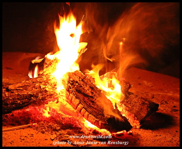
“You’ve got the watches, we’ve got the time”. Ndou’s speaking as we sit around the camp fire after dinner, the camp entirely immersed in the darkness of the African night. He’s making the point that there’s a different pace to the wilderness and that we should let go of our own perceptions of time and distance in order to fully take in the wilderness experience. He and Rhulani goes through the “programme” of the days ahead, ensuring that we understand the rules necessary to our safety while walking out in the wilderness among some of Africa’s most dangerous animals.
Most of the group opt to turn in early, leaving three of us to enjoy a last cup of coffee at the fireside. A rustle in the grass followed by an enormous splash has us grabbing for a spotlight, illuminating an impala ewe standing knee-high in the shallow pool in front of camp. We watch as she gets out of the water, and walks along the water’s edge. She disappears from sight for a second as she passes behind the trunk of a big tree next to the camp fence. Just then, there’s another tremendous splash from the water, and as the spotlight finds the impala again it is abundantly clear that her situation has turned for the worse. There’s a frantic scene playing out just meters in front of us and no one thinks to pick up a camera! A medium-sized crocodile has her body firmly in its mouth, and a hyena (or was it two?) is running up and down along the water. We watch in dumbfounded awe as the struggling impala disappears below the water, a string of bubbles rising to the surface signalling that she breathed her last. Five minutes later, the crocodile surfaces again with his now drowned prize, just for a few seconds, her eyes still open and eerily reflecting the light from our torch. We speculate that the hyenas must have chased the impala into the water the first time, and that the opportunistic crocodile then grabbed her as she walked along the pool. However it came about, the excitement of what we’d witnessed and the sounds of the crocodile thrashing in the water as it enjoyed its meal while baboons scream in horror from the trees nearby kept me awake for quite some time that night.

The drowned impala brought to the surface for a few seconds
James provided an early morning wake-up call for those finding it hard to rise Monday morning, and all of us enjoyed the coffee and rusks before heading out for our first hike. Ndou and Rhulani chose to go walking in an area known as Milaleni, a short drive into the west of the Sweni Wilderness. Our walk started off shrouded in dense mist, which only lifted much later in the morning. Regular sightings of game and birds kept our senses peaked while Ndou and Rhulani astounded us with their tracking skills and shared their extensive knowledge of the bushveld. They chose a rocky outcrop as a picturesque picnic spot before leading us back to the vehicle along the course of the Sweni.
")
Heading into the Sweni wilderness
")
Heading into the Sweni wilderness
")
Ndou showing us a Mlala-palm leave chewed by an elephant
")
Interpreting a dung-midden
")
Big trees line the Sweni
")
Crossing a dry stream bed
")
Lion track
")
Upwards to a picnic with a view
")
The Sweni area is mostly flat plains, interspersed with a few rocky outcrops
")
A deep pool in the Sweni, home to a nursery of baby crocodiles
")
Warthog fleeing from the group
")
We encountered this herd of elephants on the way back to camp
We arrived back at camp to the smells of a delicious brunch, expertly prepared by James while we were out walking. Meals are enjoyed under a large thatched roof, with a view over the Sweni stream, the crocodile pool below the camp and the muddy waterhole on the opposite bank. There’s a constant stream of wildlife heading to the water, and combined with the wide variety of birds and small animals in the camp it is very difficult to go and enjoy a siesta after brunch, for fear of missing out on any of the action!
")
The Sweni dining area
")
Wildebeest and zebra heading for the water
")
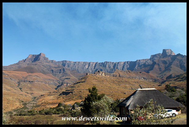
Sweni Wilderness Trail hut, July 2015
")
Red-billed hornbill
")
Yellow-fronted canaries and a blue waxbill
")
White-headed vulture coming in for a landing
")
African Open-billed Stork searching for freshwater mussels
")
View from camp
")
Thirsty impalas
")
Burchell’s starling
")
Tree squirrel
")
Baboons
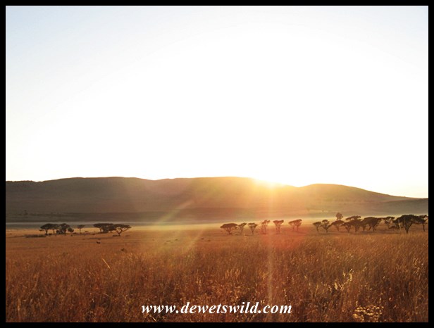
The afternoon outings take in a spot from which to enjoy the beautiful sunsets that the Lowveld is famous for. Heading eastwards to the Lebombo Mountains on Monday afternoon we spotted a selection of plains game and several species of birds – the Greater Painted Snipe we flushed as the vehicle crossed the Gwini stream causing much excitement in particular for the “twitchers” in our party. The sunset spot Ndou and Rhulani brought us to is known as Ted’s Place – a site high on a cliff in the Lebombos with the mostly dry bed of the Sweni far below and the plains of central Kruger stretching as far as the eye can see. In the distance a herd of elephant were kicking up dust on their hurried way while baboons and impalas foraged on the river bank, unworried by our presence high above them. There’s a calmness that settles over you at sunset in South Africa’s wild places, and it is easy to see why ranger Ted Whitfield enjoyed this tranquil spot so much.
")
Pair of steenbok near base camp
")
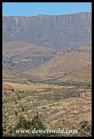
Sweni scenery
")
Black crakes
")
Elephant cows
")
Giraffes
")
Sweni sunset
")
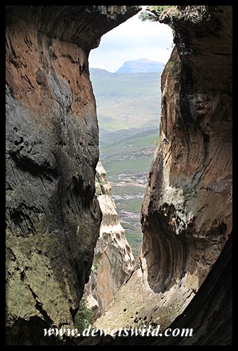
View from Ted’s Place
")
View from Ted’s Place on the Sweni Trail, Kruger National Park
That evening James had a delicious pot of stew waiting for us back at camp, and what better way to end a memorable day out in the bush than with good company and intelligent conversation around the campfire.
It’s another early wake-up accompanied by coffee, rusks and birdsong on Tuesday morning. Our ranger-guides drive us out to the Gwini-stream area again, where we’d concentrate our walking along the stream in the hopes that we’ll find the snipes again. The area literally teemed with animals and we often found ourselves among mixed herds of wildebeest, plains zebra, giraffe and impala. Rhulani pointed out a well camouflaged rock monitor lizard, hibernating high in the branches of a fever tree, and then later explained to us why the weeping wattle is also known as the “toiletpaper bush” (if you chew on the branches of this tree you’ll soon find a need for its soft leaves 😉 ).
For a long stretch of our walk we were accompanied by the shrill chattering of a Greater Honeyguide. Ndou related the local belief that if you don’t reward the honeyguide with a piece of the spoils after it has guided you to a beehive, the next time it will lead you into danger. Shortly after, with this warning still fresh in our minds, the recently placed tracks of lions we came across made us hope that Ndou and Rhulani didn’t owe this honeyguide anything!
We had our picnic rest-stop near Kally’s Fountain while curious giraffes peered at us from close by. Considering that it was the middle of a rather dry winter season the amount of water simply flowing out of the muddy soil at this spot was astounding and from the tracks in the area it was clear that it was also a favourite drinking and wallowing place for the area’s wildlife.
It was not long after picking up our backpacks again and continuing along the stream that we passed a herd of giraffe that seemed less worried about us and more concerned with something else moving through the savanna on their other side. Walking into a clearing, we were thrilled to see three lionesses and about a dozen tiny cubs heading towards a thicket some 200m ahead of us. We enjoyed the sighting from a safe distance, as lion mothers are notoriously aggressive and extremely dangerous. They quickly rushed the cubs to the safety of the thicket and Ndou and Rhulani then steered us in the direction of the vehicle. While we didn’t see the lions again I’m sure they kept a watchful eye on us as we walked past!
")
Sweni sunrise
")
Grey heron
")
Pool in the Gwini
")
Can you see the hibernating monitor lizard?
")
Blue wildebeest on the run
")
Rhulani, our guide on the Sweni Trail, explaining why a Weeping Wattle can also be called a “toiletpaper bush”
")
Enjoying wildlife along the way
")
Plains zebras making their escape
")
Curious giraffe
")
Kally’s Fountain
")
Kally’s Fountain
")
Kally’s Fountain
")
Kally’s Fountain
")
Gwini stream
")
Lionesses and cubs
")
Funnelweb spider’s nest
")
Pearl-Spotted Owlet
Back at camp it was time for another scrumptious brunch and then more opportunities to enjoy the real-life wildlife documentary playing out around the waterhole. The satiated crocodile was baking in the sun at one end of the pool while Egyptian Geese were noisily laying claim to the other. All around us tiny birds were flitting about the branches while wildebeest, zebra, giraffe, bushbuck, kudu and impala put in appearances at the water’s edge. In the late afternoon a big herd of elephants came to slake their thirst from the pool in front of camp, and it was a difficult decision whether to stay in camp enjoying their antics or to head out into the wilderness for one final sundowner walk.
")
Killer crocodile
")
Egyptian goose
")
The view from the Sweni Trails Camp
")
Chinspot Batis (female)
")
Black-backed Puffback
")
Elephant cow
")
Watching elephants from the Sweni camp
")
One elephant, or three?
I am glad everyone decided to go out for that last walk in the wilderness with ranger guides Ndou and Rhulani, as it turned out to be the absolute highlight of an already memorable wilderness trail. We drove to the Milaleni area again, to enjoy a short walk to a waterhole in the bed of the Sweni before returning to a low rocky ridge from where we could appreciate another spectacular sunset.
We spotted the agitated elephant bull on the opposite bank of the Sweni as we got off the vehicle, but it seemed he was moving off and we weren’t too perturbed. Not ten minutes later, we had spotted another pride of lions, more relaxed and with slightly older cubs than those we saw that morning. With our attention focused on the lions as we crossed over to the other bank, we didn’t immediately notice that the elephant bull was still in the area and quite close (I’m sure the rangers knew he was there though). With head held high he was making it clear that we shouldn’t follow. And so we found ourselves between a huge and unfriendly elephant bull and a large pride of lions. Eventually the lions realised that we had seen them and the adults moved to cover, while the curious cubs did a poorer job at hiding. The elephant at our back had also moved on and satisfied with our viewing we moved away from the scene as well.
Ndou found a Magic Guarri bush and was busy telling us about how it could be used for anything from a useful toothbrush and fire-fighting tool, its uses in traditional medicine and how it wards of ghosts from your home, when the sounds of hippos rushing to water had us all alert. It seemed hippos have taken up residence at the waterhole to which we were heading and to add to the gravity of the situation Rhulani also reported that a herd of elephant was feeding around the waterhole. Our rangers then explained the dangerous situation in which we found ourselves as we had to pass the waterhole to get back to our vehicle at the sundowner spot. With the sun setting fast, we couldn’t wait the situation out and with the wind against us we couldn’t go back past the lions along the track we came. Having reminded us of the rules and what they expected from us, the rangers lead us closer to the pool.
Peering through the bush we could see a huge hippo bull standing tall in the water as Ndou took up position in the stream bed, facing Africa’s most dangerous mammal. There was simply no time for photos as Rhulani led us behind Ndou and up onto the opposite bank of the river. At this point, the herd of elephants became aware of our presence and sounded their dissatisfaction. Some of the herd, mostly cows with calves, thundered away while especially the younger males gave impressive threat displays. We in turn were following Rhulani in single file heading straight back to the vehicle at brisk pace as Ndou caught up from behind. What an adrenalin rush! Pretty soon a couple of jackals started yelping, probably complaining that the lions, elephants and hippos failed to deliver them some tasty morsels!
It was a supercharged group of trailists that clambered onto that rocky ridge that evening. The show however was not over. As we unpacked our snacks and opened our drinks, we all found a spot from where we could take in our final Sweni spectacular. With the glowing red of an African sunset surrounding us, the lions started roaring. You could feel their booming voices resonating in your chest. From a distance more lions started roaring, moving closer at speed. Must be the males coming to join the rest of the pride! Through binoculars in the fading light we could make out their shapes as they moved up the opposite bank. Every now and then a hippo would chime in with a grunt or an elephant’s trumpeting would silence the almost constant calling of the jackals. The sweet whistles of a fork-tailed drongo coming from a knob-thorn just behind us provided such contrast to the bellowing of the big mammals. And then, the rasping roar of a leopard, very close but out of sight, provided the closing notes to the African symphony. The curtains were drawn on one of the most memorable experiences I’ve ever had in South Africa’s wild places.
")
Waterbuck bull
")
Suckling elephant calf
")
Elephant calf playing with the dust
")
Impala on the run
")
Two tracks leading into the Wilderness
")
Crossing the Sweni while the elephant moves away
")
Only he is still around, and not amused!
")
The lions lying on the other side
")
The cubs were too curious to hide
")
Ndou demonstrating how to brush your teeth with a Magic Guarri stem
")
Surprised elephant herd
")
Marching out of danger
")
Disappointed jackal
")
Sunset spot
")
Another Sweni sunset
That night, after a delicious traditional meal of pap-en-braaivleis (barbecued meat with maize meal porridge) we reflected around the campfire about the experiences we shared the last couple of days, the professionalism and extraordinary knowledge of the two rangers that guided us, safely, through the Sweni wilderness, and the way the wilderness makes friends of strangers.
")
Chatting at the fireside
")
Nighttime view from Sweni
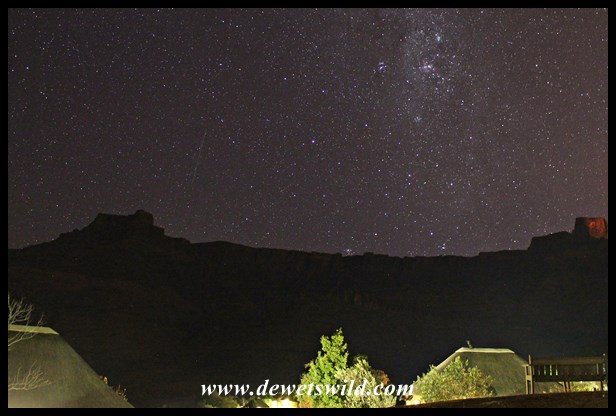
")
The Milky Way above Sweni Wilderness Trails Camp
WIth heavy hearts we had to vacate the Sweni Trails Camp on Wednesday morning, to be delivered back to Satara and civilisation. A honey badger came to wish us goodbye at the camp, and after savouring James’ home-baked bread for the last time we’re on our way.
")
Honey Bagder
")
Spotted hyena
At Satara it is time to bid farewell to rangers Ndou and Rhulani and to newly made friends Verna, Sinmarie, Shareen, Hanneli, Ronel and Cerita. Four of the group would have a few more days in the Park, four of us (including Ansie and me) were headed to Orpen Gate and back to Pretoria, and the two rangers would that afternoon take a different group back with them to the wonderful Sweni Wilderness Trails Camp. How we envied those lucky souls!
")
Big elephant bull just outside Satara
")
The crocodiles at Nsemani Dam seems to have acquired a new fashion of mud on their backs 😉
")
The crocodiles at Nsemani Dam seems to have acquired a new fashion of mud on their backs 😉
")
Southern White-crowned Shrike
")
Ground hornbill
")
Little Bee-eater
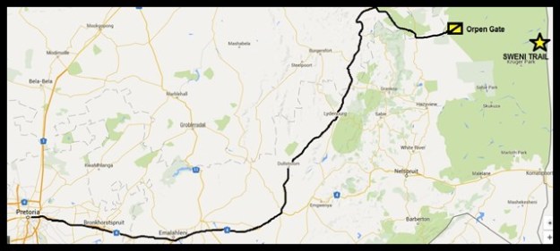
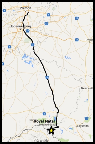
Orpen Gate, and Sweni Wilderness Trail, to Pretoria via Lydenburg (map drawn with Google Maps)
The Sweni Wilderness Trail is one of seven operated by SANParks in the Kruger National Park.
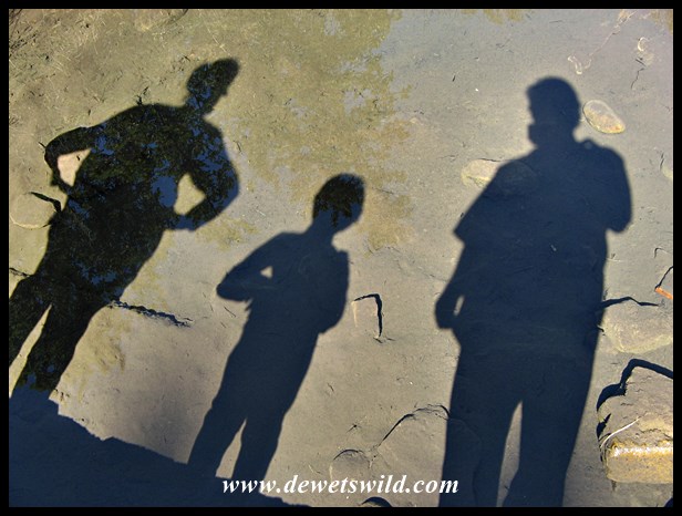
The story of our three magical days on the Sweni trail is a perfect fit for the WordPress Weekly Photo Challenge “Today was a Good Day“
")
")
")
")
")
")
")
")
")
")
")
")
")
")
")
")
")

")
")
")
")
")

")
")
")
")
")
")
")
")
")
")
")
")
")
")
")
")
")
")
")
")
")
")
")

")
")
")
")
")
")
")
")
")
")
")
")
")
")
")
")
")


")
")
")
")
")
")
")
")
")
")
")
")
")
")
")
")
")
")
")
")
")
")


")
")
")
")
")
")
")
")
")
")
")
")
")
")
")
")
")
")
")
")
")
")
")
")
")
")
")


")
")
")
")
")
")
")
")
")
")
")
")
")
")
")
")
")
")
")
")
")
")
")
")
")
")
")
")
")
")
")
")
")
")
")
")
")
")
")
")
")
")
")
")
")
")
")
")
")
")
")
")
")
")
")
")
")
")
")
")
")
")
")
")
